Storms Targeting Orlando and Central Florida Saturday With 3 Inch Rainfall Possible Before Sunday Storms Shift to Daytona Beach and Cocoa Beach
ORLANDO, FL — Central Florida is facing a two-day active storm pattern beginning Saturday evening, June 13, with big downpours and thunderstorms targeting the Orlando corridor between 6 and 11 p.m. before the storm focus shifts Sunday to the I-95 corridor and Atlantic beach communities from Daytona Beach through Cocoa Beach — all while temperatures hold stubbornly in the mid-90s across the region through the coming week.
Saturday Evening Storm Threat
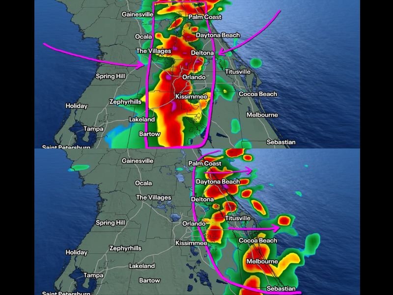
Fox 35 Orlando Storm Team forecast model imagery valid Saturday at 9:00 p.m. shows intense red and orange reflectivity cores concentrated across a broad corridor from Ocala and The Villages southward through Orlando, Kissimmee, Lakeland, and Bartow — with the primary storm zone highlighted in a pink polygon encompassing the heart of Central Florida’s most populated communities.
The late start to storm development Saturday means the atmosphere will have spent the entire day building instability, resulting in tremendous lightning rates and heavy rainfall from any storms that fire. Localized totals of 3 inches or more are possible in a short period within the most intense cells. One or two storms could briefly reach severe criteria, though widespread severe weather is not the primary concern — rainfall rates and lightning are.
Sunday Shift to the Coast
Sunday’s storm focus shifts eastward to the I-95 corridor and Atlantic beach communities that have seen limited rainfall activity recently. Daytona Beach, Deltona, Titusville, Cocoa Beach, and Melbourne are all highlighted in Sunday’s evening storm zone, with Fox 35 forecast imagery valid Sunday at 10:00 p.m. showing active cores developing along and east of the I-95 corridor toward the Atlantic shoreline.
Plentiful evening storms and downpours are expected across the beach communities Sunday, providing meaningful rainfall to areas that have been relatively dry during recent storm cycles.
Week Ahead for Orlando
The seven-day outlook for the Orlando area shows highs holding at 93 to 95°F with overnight lows in the mid to upper 70s through Friday. Daily storm chances settle at 40% Monday through Friday following the more active Saturday and Sunday, with temperatures showing no signs of relief from the persistent mid-90s pattern that has dominated Central Florida through mid-June.
For continuing coverage of Central Florida storm threats and weather across the United States, visit SaludaStandard-Sentinel.com.