Morning Thunderstorm Complex Pushing Through Southern Iowa With Tornadoes and 80 MPH Winds Possible as the System Expands Toward Cedar Rapids and Des Moines
DES MOINES, IA — A dangerous morning complex of thunderstorms was tracking through southern Iowa at 5:52 a.m. Thursday, June 11, with tornadoes and destructive wind gusts up to 80 mph possible as the system pushed eastward and was expected to expand further north into eastern Iowa toward Cedar Rapids as it progressed through the midmorning hours.
What Radar Showed at 5:52 AM
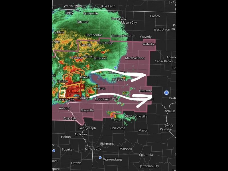
Radar at the time of the 5:52 a.m. update revealed an expansive and intense storm complex covering a broad swath of southwestern Iowa, with deep red and orange reflectivity cores clustered near Nebraska City, Clarinda, and the Atlantic corridor along the Nebraska-Iowa border. Multiple warning polygons — depicted in red and orange on the radar — were active simultaneously across the most intense portion of the complex, confirming active severe weather was ongoing at the time of the scan.
The storm system’s leading edge was tracking eastward across southern Iowa through Des Moines, Indianola, Creston, and Mount Ayr, with the arrow annotations on the radar image indicating two primary storm tracks pushing toward Ottumwa and the southeastern Iowa corridor.
Expanding Threat Toward Cedar Rapids
Beyond the immediate southern Iowa threat, forecasters warned the complex was expected to expand further north into eastern Iowa as it moved through midmorning. Cedar Rapids — one of Iowa’s largest cities — sat in the projected expansion zone, meaning the storm’s coverage area was anticipated to grow rather than contract as it moved through the state during the morning commute hours.
Waterloo, Marshalltown, and Fort Dodge all fell within the broader watch area as the complex continued organizing and pushing eastward across the state.
Active Warning Zone
A large severe weather watch polygon covered virtually all of southern and central Iowa at the time of the update, extending southward into northwestern Missouri near Trenton, Milan, and Kirksville. The watch boundary confirmed meteorologists anticipated continued severe storm potential across the entire region through at least midmorning as the complex maintained intensity moving away from its initiation zone near the Nebraska border.
Morning Safety Actions
Iowa residents in the path of this complex should shelter immediately in the lowest interior room of a sturdy building and avoid all travel until warnings in their county expire.
For continuing coverage of Iowa severe weather and storm threats across the United States, visit SaludaStandard-Sentinel.com.