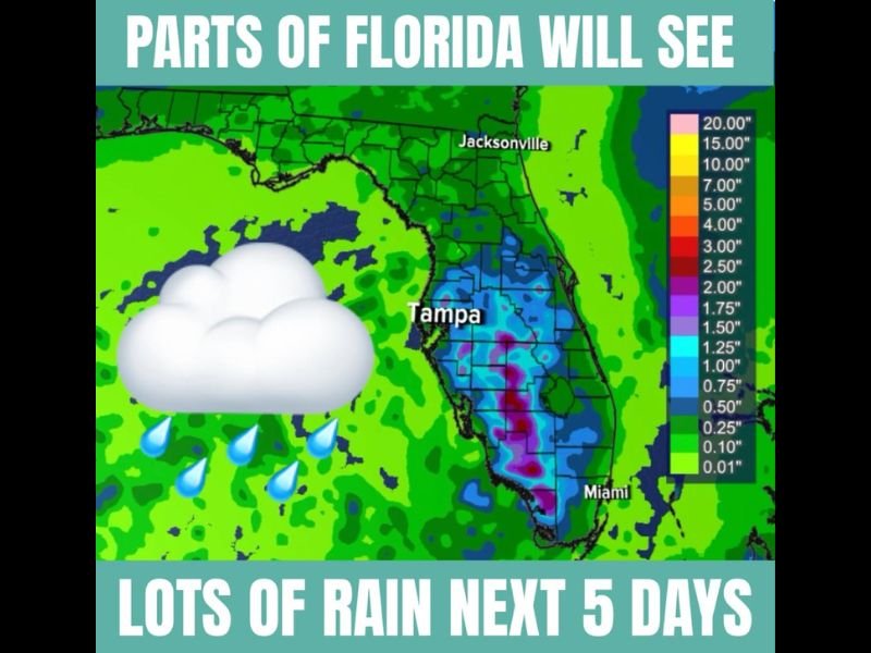
Heavy Rainfall Totals of 2 to 3 Inches Expected Across Central and South Florida Over the Next Five Days With the Greatest Accumulations South of Tampa and Orlando
TAMPA, FL — Central and southern Florida are set to be the biggest rainfall recipients over the next five days, with forecast accumulation maps showing 2 to 3 inches or more possible across the corridor between the coasts and south of the I-4 corridor, while northern Florida communities including Jacksonville, Tallahassee, Panama City, and Pensacola face a much drier and more isolated storm pattern through the period.
Where the Rain Falls Heaviest
The five-day rainfall accumulation forecast depicts the most concentrated precipitation totals across the interior of the Florida Peninsula from the Tampa-Orlando corridor southward toward Miami and the southern tip of the state. The deepest purple shading on the accumulation map — representing the highest localized totals — is focused across south-central Florida, with some locations between the coasts potentially seeing isolated pockets exceeding 2.50 to 3 inches over the five-day window.
The pattern favors areas situated between the Gulf Coast and Atlantic Coast rather than directly on either shoreline, as sea breezes converging inland from both coasts will act as the primary trigger for daily afternoon storm development and rainfall accumulation through the period.
Northern Florida Stays Drier
North of the I-4 corridor, the rainfall picture changes significantly. Jacksonville, Tallahassee, Panama City, and Pensacola will see far fewer pop-up storms through the five-day period, with rainfall remaining more isolated and totals staying well below what central and southern communities will accumulate. Residents in the northern tier of the state should not expect meaningful drought relief from this pattern.
Weekend Beach Outlook
For Floridians planning beach outings this weekend, the west coast of Florida offers a better overall outlook compared to the east coast. Storms that do develop will tend to track from west to east, meaning Gulf-side beaches are more likely to see storms pass through quickly while Atlantic-side beaches face a higher likelihood of storms arriving during afternoon and evening hours.
Flash Flooding Awareness
Any location south of Orlando receiving multiple rounds of 2 to 3 inch rainfall events across consecutive days should monitor for localized flash flooding in low-lying areas, poor drainage neighborhoods, and areas already saturated from recent rainfall.
For continuing coverage of Florida rainfall and weather patterns across the United States, visit SaludaStandard-Sentinel.com.