Flash Flood Risk Rises This Weekend Into Next Week as Birmingham, Tuscaloosa, and Anniston Could See 5″+ of Rain With Heat Index Near 100°
ALABAMA — A multi-layered weather threat is building across Alabama heading into the weekend and continuing into next week. Near-term conditions today feature partly to mostly sunny skies with isolated afternoon popup showers, but the pattern shifts significantly as a stalling front arrives this weekend, dramatically increasing storm chances and bringing a serious flash flooding risk to a large portion of the state.
Heat Index Approaching Triple Digits Before the Weekend
Highs near 90°F are expected today and again tomorrow, with heat index values approaching triple-digit levels both days. Some heat index readings could top 100°F this weekend even as storm chances increase during the afternoon hours.
Residents should stay hydrated, limit prolonged outdoor exposure during peak afternoon heating, and never leave children or pets in vehicles. Saturday still offers plenty of morning time for lake and pool activities, but afternoon storms will need to be watched closely.
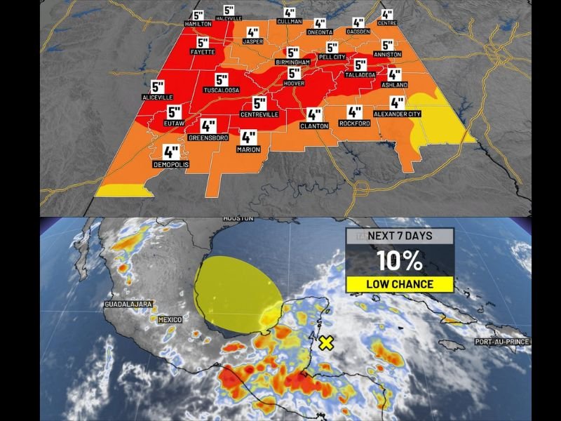
5 Inches of Rain Possible Across Central Alabama as Front Stalls
The most significant concern heading into the weekend and next week is the flash flooding potential as a front moves in and stalls over the region. Rainfall totals over the next seven days could exceed 5 inches across a wide swath of central Alabama, including Birmingham, Tuscaloosa, Hoover, Pell City, Talladega, Anniston, Centreville, Fayette, Aliceville, and Eutaw.
Areas including Hamilton, Haleyville, Cullman, Oneonta, Gadsden, and surrounding communities are forecast to see 4 to 5 inches of rainfall through early next week. Forecasters are already monitoring for possible First Alert Weather Days tied to flooding risk as guidance signals increasingly heavy rainfall totals.
Tropical Disturbance Moving Into Southwest Gulf Being Monitored
A tropical disturbance that models had been signaling is now showing up and is expected to move into the southwest Gulf over the coming days. Development chances remain low at this time, with models currently favoring a northwestward track.
However, any shift toward a more northward or eastward track would need to be monitored closely for potential additional moisture impacts on the region.
Stay with saludastandard-sentinel.com for the latest weather updates and local forecast coverage.