SPC Level 1 Severe Weather Outlook Targeting Iowa Missouri and Kansas Saturday as Surface Low and Missouri Valley Instability Fuel Afternoon and Evening Storm Chances
KANSAS CITY, MO — The Storm Prediction Center has introduced a Level 1 of 5 severe weather outlook for Saturday, June 13, across portions of Iowa, Missouri, and Kansas, with a surface low pressure system parked over the central High Plains and a frontal boundary drawing moderate to strong atmospheric instability up the Missouri Valley corridor — setting the stage for afternoon and evening storm development across the region.
What the Outlook Shows
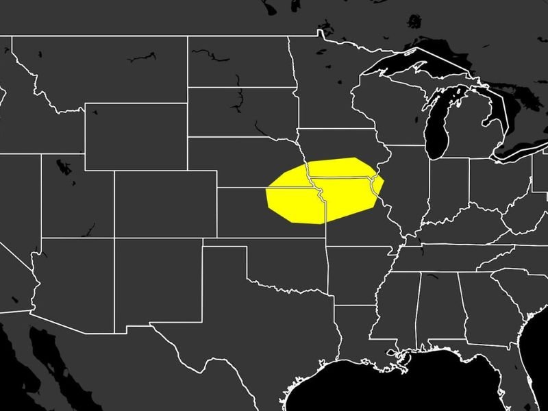
The Day 4 SPC probabilistic outlook updated June 10 at 4:30 a.m. ET depicts a 15% severe weather probability zone covering a focused corridor straddling the Iowa, Missouri, and Kansas border region. The yellow-shaded area on the outlook map is relatively compact at this range, reflecting the inherent uncertainty still present four days out from the event, but the signal is clear enough that forecasters have introduced the risk area for monitoring purposes.
The surface low pressure system expected to sit over the central High Plains Saturday will act as the primary forcing mechanism, drawing a frontal boundary across the Missouri Valley and concentrating the most favorable instability and wind shear in that corridor during the afternoon and evening hours.
Why the Missouri Valley is the Focus
The Missouri Valley corridor running through eastern Kansas, western Missouri, and southern Iowa represents the convergence zone where moisture, instability, and wind shear are most likely to overlap Saturday afternoon. Frontal boundaries in this region are known to serve as focal points for storm initiation, particularly when a surface low is simultaneously drawing energy northward from the Gulf of Mexico.
Afternoon heating along and ahead of the front will further destabilize the atmosphere, increasing the potential for organized convection to develop during the peak heating hours and persist into the evening.
Four Days Out — Still Watch and Wait
With Saturday still four days away at the time of this outlook issuance, forecasters emphasize that the exact position and intensity of the risk area will shift as additional model data becomes available. The current 15% probability zone should be treated as an early signal rather than a definitive forecast, and residents across Iowa, Missouri, and Kansas should monitor updates through the week.
For continuing coverage of developing severe weather outlooks across the United States, visit SaludaStandard-Sentinel.com.