Scattered Storms With Heavy Rain and Gusty Winds Moving Into North Carolina Wednesday as Highs Climb to the Low 90s Across Fayetteville Raleigh and the Eastern Half
RALEIGH, NC — North Carolina is entering a somewhat unsettled Wednesday, June 10, with a weather system pushing from northwest to southeast across the state through the afternoon and evening, bringing scattered showers and thunderstorms capable of heavy rainfall bursts and gusty winds while temperatures climb into the low 90s across central and eastern communities.
Morning and Afternoon Conditions
The day begins quietly across most of North Carolina, with partly sunny skies expected from late morning through the afternoon for the majority of the state. A couple of isolated showers cannot be ruled out across the northwestern corner of the state early in the day, but widespread storm activity is not anticipated until the afternoon hours as the approaching system gains organization.
Southwest winds at 5 to 20 mph will transport increasing moisture into the state through the day, setting the stage for storm development as afternoon heating destabilizes the airmass across the Piedmont and eastern regions.
Storm Coverage and Hazards
Scattered showers and thunderstorms are expected to develop across the mountains and foothills first before spreading into central and eastern North Carolina through the afternoon and evening hours. Coverage will be hit or miss, meaning not every community will experience storms, but those that do encounter a cell could see heavy rainfall bursts and gusty winds as the primary hazards.
The northwest to southeast storm track will bring the most organized activity into the Piedmont corridor including Greensboro, Charlotte, and Raleigh during the afternoon, before pushing into eastern communities including Fayetteville, Kinston, and Wilmington through the evening hours.
Temperature Spread Across the State
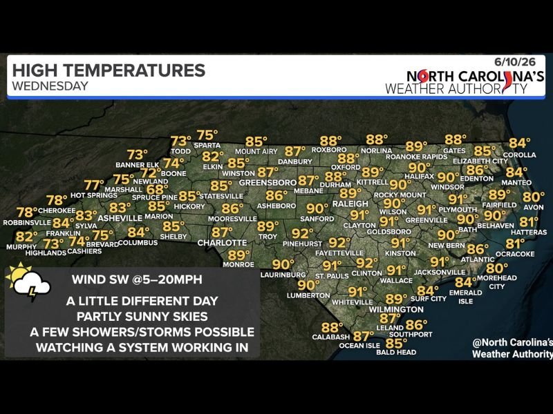
High temperatures Wednesday will range from the 70s across western mountain communities to the low 90s across the eastern half of the state. Fayetteville and Pinehurst will top out at 92°F, Raleigh reaches 90°F, and Charlotte climbs to 87°F. Greensboro will hit 85°F while Asheville and western communities stay in the low to mid-80s. Mountain communities including Boone, Banner Elk, and the highest elevations will remain in the low to mid-70s throughout the day.
Residents across central and eastern North Carolina should keep weather alerts active through the evening as storm timing and coverage will continue to be refined.
For continuing coverage of North Carolina weather and storm threats across the United States, visit SaludaStandard-Sentinel.com.