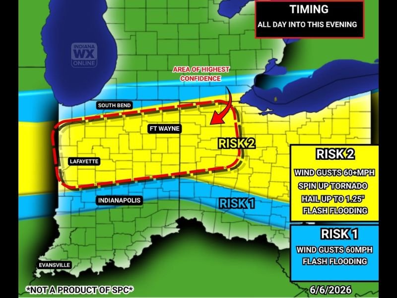
Multiple Storm Rounds Bring Flash Flooding 60 MPH Winds and Hail Risk Across Indiana From Fort Wayne to Indianapolis All Day Into Saturday Evening June 6
INDIANAPOLIS, IN — Multiple rounds of thunderstorms are impacting Indiana throughout Saturday June 6, 2026 with the first round already moving through the state and a second more significant round expected to develop along a remnant surface boundary south of US-24 and north of Interstate 70 after 3:00 PM EDT, bringing a conditional severe weather risk featuring 60 mile per hour wind gusts, spin-up tornado potential, hail up to 1.25 inches, and flash flooding with rainfall rates potentially exceeding 1.5 inches per hour across the affected corridor.
Two Distinct Risk Zones Across Indiana
Indiana WX Online severe outlook for June 6, 2026 identifies two clearly defined risk zones across the state with different hazard profiles for each area during the all-day into evening storm timeframe.
The Risk 2 zone representing the highest confidence area is outlined in red dashed boundaries encompassing the Fort Wayne, South Bend, and Lafayette corridor across northern and north central Indiana, where all four primary hazards including 60 plus mile per hour wind gusts, spin-up tornado risk, hail up to 1.25 inches, and flash flooding are all simultaneously possible during the afternoon and evening storm rounds.
Flash Flood Threat Dominates the Hazard Profile
Despite the multi-hazard nature of Saturday’s storm potential, forecasters identify flash flooding and excessive rainfall as the primary and most widespread concern across both risk zones given the pulse storm nature of the expected afternoon convection and the limited and unidirectional wind shear that will characterize the atmospheric environment during the second storm round.
Rainfall rates exceeding 1.5 inches per hour within the most intense storm cores will create the potential for rapid water accumulation in urban areas, underpasses, low lying roadways, and communities along small streams and creeks throughout the Indianapolis, Fort Wayne, and Lafayette corridors during the afternoon and early evening hours as the second storm round develops and tracks along the surface boundary.
Conditional Severe Risk Depends on Atmospheric Recovery
The severity of the afternoon storm round carries an important conditional element that forecasters emphasize hinges entirely on how well the atmosphere recovers between the first morning storm round and the afternoon convective initiation expected along the surface boundary south of US-24 and north of Interstate 70.
If the morning storms sufficiently stabilize the atmosphere by removing available instability, the afternoon severe weather potential will be limited and primarily confined to flash flooding concerns from pulse type storm cells. If recovery is more complete, conditions become increasingly favorable for the full range of Risk 2 hazards including the brief spin-up tornado risk along the surface boundary during the peak afternoon heating window.
For continuing coverage of Indiana severe weather and storm impacts across the United States, visit SaludaStandard-Sentinel.com.