European and Google Models Signal Potential Tropical Development Over the Gulf of Mexico by Mid June 2026 as Hurricane Season Monitoring Intensifies
MIAMI, FL — Thursday afternoon ensemble model data is raising early awareness of a potential area of tropical development over the Gulf of Mexico during the mid June 2026 timeframe, with the European ECMWF ensemble probability map and Google AI model tracks both independently signaling the possibility of a tropical depression or low pressure system organizing over the Gulf by around June 15 to 16, though forecasters emphasize the situation remains far too uncertain at this range to draw firm conclusions about development or track.
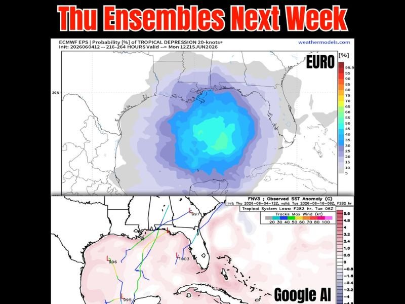
European Ensemble Paints a Broad Gulf Coverage Zone
The ECMWF EPS probability map valid for Monday June 15, 2026 shows a broad swath of blue and cyan shading covering the majority of the Gulf of Mexico basin, indicating a 35 to 50 percent probability of tropical depression level circulation of 20 knots or greater developing somewhere within that zone during the forecast window.
The coverage of the probability field is notably expansive, encompassing virtually the entire Gulf of Mexico from the Mexican coast northward toward the Louisiana and Texas shoreline and eastward toward Florida, reflecting the high degree of uncertainty about exactly where any potential development might focus within the broader favorable moisture environment expected to be in place across the basin during that period.
Google AI Model Tracks Add Supporting Signal
The Google AI FNV3 model initialized June 4 and valid through June 16 shows multiple ensemble track solutions originating from low pressure systems positioned over and near the Gulf of Mexico during the mid June window, with tracks spreading across a wide range of directions including northward toward the Louisiana and Texas coast and eastward toward Florida.
The presence of both the European ensemble probability signal and independent Google AI model track solutions suggesting Gulf low pressure activity during the same general timeframe adds modest confidence to the idea that the Gulf of Mexico deserves close monitoring heading into the second and third week of June 2026.
Too Early for Alarm but Worth Watching
Forecasters are clear that ensemble model data at the 9 to 11 day range carries substantial uncertainty, and the broad probability footprint on the European map reflects that uncertainty rather than indicating high confidence in development at any specific location within the Gulf.
The primary concern regardless of whether any formal tropical development occurs remains the abundant tropical moisture that will be streaming northward into the Gulf Coast region during this period, with heavy rainfall and flooding potential representing a significant threat for Gulf Coast communities whether or not a named system ultimately develops from the disturbance.
For continuing coverage of Gulf tropical developments and hurricane season monitoring across the United States, visit SaludaStandard-Sentinel.com.