Isolated Severe Capable Storms Developing Across Arkansas With Strong Winds and Hail Possible Near Conway Pine Bluff and Monticello Sunday Afternoon
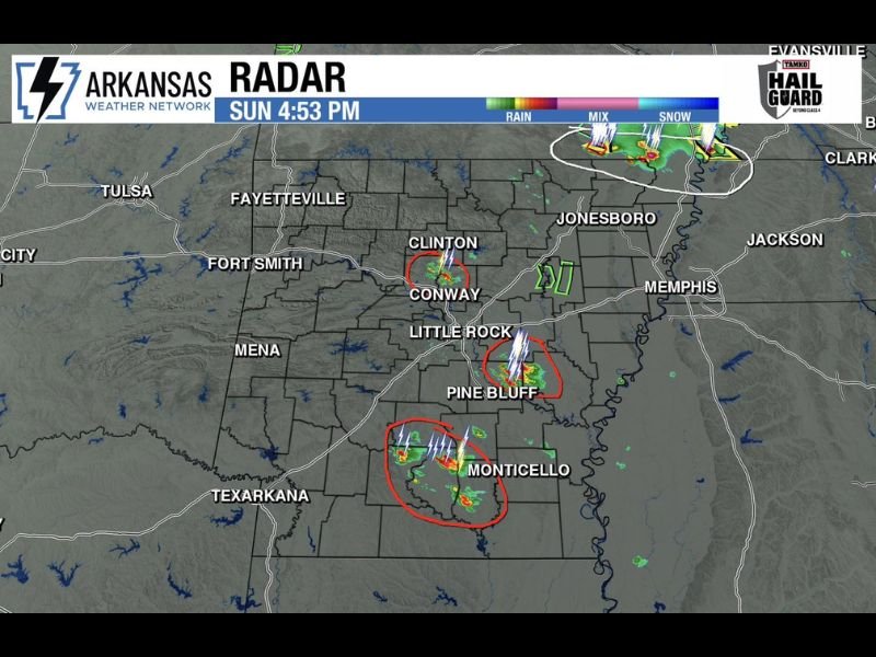
LITTLE ROCK, AR — Isolated thunderstorms capable of producing strong winds and hail are developing across a highly unstable Arkansas atmosphere Sunday afternoon, with Arkansas Weather Network radar captured at 4:53 PM showing several distinct storm cells firing across central and southern Arkansas near Conway, Pine Bluff, and Monticello while severe storms and tornado warnings in southeast Missouri threaten to clip the northeastern corner of the state.
Multiple Storm Cells Firing Across Central and Southern Arkansas
Radar imagery at 4:53 PM Sunday shows three primary areas of storm concern across Arkansas, with isolated cells displaying intense lightning activity and moderate to heavy precipitation cores developing in a very unstable atmospheric environment across the central and southern portions of the state.
The Conway and Clinton area in central Arkansas shows an active storm cell circled as a potential severe weather concern, while a second significant cell with prolific lightning activity is developing near Pine Bluff south of Little Rock, and a third notable cell is firing near Monticello in southeastern Arkansas, all operating within an environment capable of supporting strong wind gusts and hail production.
Southeast Missouri Tornado Threat Could Clip Northeast Arkansas
The most significant severe weather concern of the afternoon involves an organized cluster of severe storms and active tornado warnings located in southeast Missouri, which forecasters are monitoring closely for potential impacts on the northeastern counties of Arkansas as the system tracks in a direction that could bring it into the state’s northeastern corner.
Communities across northeastern Arkansas including the Jonesboro area and surrounding counties are advised to remain weather aware through the Sunday evening hours as the southeast Missouri severe weather situation continues developing and its southward or southeastward extent becomes clearer with updated radar analysis.
Unstable Environment Supports Additional Development
The atmospheric environment across Arkansas Sunday afternoon is described as very unstable, meaning additional isolated storm development beyond what is currently depicted on radar cannot be ruled out as daytime heating continues maximizing instability values across the region through the early evening hours.
Strong winds and hail remain the primary threats associated with any storms that reach severe limits across Arkansas during this event, with the tornado threat considered low but not entirely absent given the overall atmospheric instability in place across the state.
Hot and Steamy Where Storms Have Not Reached
Across the vast majority of Arkansas where storm activity has not yet developed as of the 4:53 PM radar snapshot, conditions remain oppressively hot and humid with the combination of heat and high moisture content creating an uncomfortable and steamy environment for residents throughout the afternoon and into the evening hours.
For continuing coverage of Arkansas storm development and severe weather tracking across the United States, visit SaludaStandard-Sentinel.com.