Powerful Looking but Scattered Afternoon Thunderstorms Roll Through Arkansas With Lightning Prompting Water Safety Warnings Near Marked Tree This Afternoon
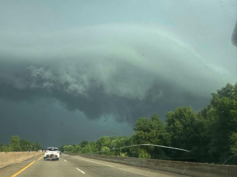
MARKED TREE, AR — A visually dramatic and imposing thunderstorm was photographed near Marked Tree, Arkansas this afternoon, with the storm’s dark and turbulent cloud structure drawing considerable attention from residents and motorists across the region despite forecasters confirming the system carries considerably more visual intimidation than actual severe weather threat for most of the state.
Storm Looks Worse Than It Is
The striking photograph captured near Marked Tree shows an ominous and shelf-cloud-like storm structure rolling across the Arkansas landscape with a dark green and grey tinted sky beneath the storm base, a visual presentation that often signals the leading edge of a stronger thunderstorm cell pushing outward ahead of its most intense rainfall core.
Despite the dramatic appearance, forecasters indicate this particular storm falls into the category of a stronger afternoon convective cell rather than a severe thunderstorm, meaning while it commands respect and attention it does not reach the threshold for damaging wind, large hail, or tornado production that would trigger formal severe weather warnings across the affected area.
Scattered and Spotty Storm Coverage Statewide
The Marked Tree storm is part of a broader pattern of very scattered and spotty afternoon thunderstorm activity developing across Arkansas during the warm and humid afternoon hours, with individual cells popping up in isolated fashion across the state rather than organizing into any cohesive or widespread severe weather system.
This type of scattered afternoon convection is a characteristic feature of Arkansas summer and late spring weather, driven by daytime heating working against a warm and moisture-laden atmosphere that provides sufficient instability for individual storm cells to develop and produce locally heavy rainfall and lightning even in the absence of strong large-scale atmospheric forcing.
Lightning Remains a Serious Concern
While the storm may not reach official severe weather thresholds, forecasters are emphatic that lightning activity within these afternoon cells represents a genuine and potentially deadly hazard that demands immediate action from anyone near lakes, pools, or other open water locations across the region.
The standard guidance applies firmly to today’s storm environment: at the first sound of thunder, anyone in or near water should exit immediately and seek substantial shelter indoors or within a hard-topped vehicle until at least thirty minutes have passed since the last thunder was heard in the area.
Warm and Humid Conditions Continue
Beyond the isolated storm threat, the dominant weather story across the vast majority of Arkansas this afternoon remains the oppressive combination of heat and humidity that is typical of this transitional period between late spring and the early summer season.
Residents are encouraged to stay hydrated, limit outdoor exertion during peak afternoon heating hours, and keep a close eye on rapidly developing storm cells that can intensify quickly under these atmospheric conditions. For continuing coverage of Arkansas weather and severe storm activity across the United States, visit SaludaStandard-Sentinel.com.