Gulf Moisture Arrives Thursday Morning as Florida Storm Pattern Shifts From Late Day to Morning Showers and Storms Across the Tampa Bay Region
TAMPA, FL — A notable shift in Florida’s daily storm pattern is underway as Gulf of Mexico moisture advancing toward the peninsula is set to bring morning showers and storms to the Tampa Bay region beginning Thursday, marking a departure from the typical late afternoon and evening convective cycle that Florida residents experience through much of the warm season.
Live Radar Shows Gulf Moisture on the Move
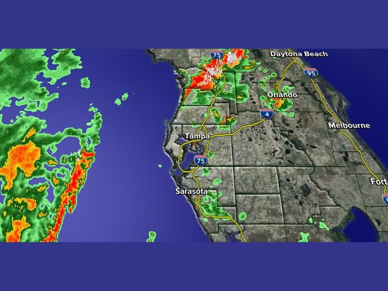
Tampa Bay live radar captured at 9:00 PM Wednesday evening shows a broad and active precipitation field positioned over the Gulf of Mexico to the west of the Florida Peninsula, with numerous pockets of heavy rainfall indicated by deep orange and red returns embedded within the advancing moisture shield.
The system is clearly organized and carrying substantial rainfall potential as it tracks eastward toward the Gulf Coast, with the timing of its arrival placing the heaviest impacts squarely within the Thursday morning window rather than the afternoon hours when Floridians are more accustomed to seeing storm activity develop across the peninsula.
Pattern Flip From Afternoon to Morning Storms
The most significant meteorological development signaled by this radar presentation is the impending flip in the daily storm timing cycle across the Tampa Bay area and surrounding regions.
Florida’s warm season storm pattern is heavily dominated by afternoon and evening convection driven by sea breeze interactions and daytime heating, making morning storm activity comparatively unusual. The arrival of organized Gulf moisture overrides the typical sea breeze mechanism and pushes precipitation activity into the morning hours, a pattern shift that forecasters indicate will persist as the Gulf system continues influencing the regional weather setup in the coming days.
Areas Expected to Feel the Impact
The Tampa Bay metropolitan area sits directly in the path of the advancing Gulf moisture, with communities across Hillsborough, Pinellas, Manatee, and Sarasota counties positioned to receive Thursday morning rainfall as the system pushes onshore from the west.
Meanwhile, radar at 9:00 PM Wednesday also shows active storm cells already firing along the north-central Florida Peninsula near the Interstate 75 corridor north of Tampa, with additional activity visible near the Orlando metro area suggesting the broader moisture environment is already primed across multiple portions of the state.
What Residents Should Expect Thursday
Residents across the Tampa Bay region should anticipate a wetter than typical Thursday morning commute, with showers and storms possible during the hours when roads are most heavily traveled.
The shift toward morning storm activity represents a change from recent days and is expected to continue as Gulf moisture remains the dominant influence on the regional weather pattern in the near term period ahead. For continuing coverage of Florida weather developments and Gulf Coast storm tracking, visit SaludaStandard-Sentinel.com.