Severe Risk Targets West and Central Texas Tuesday Through Tuesday Night With Tennis Ball Hail Tornadoes and 70 MPH Winds Threatening the Midland San Angelo and Del Rio Corridor
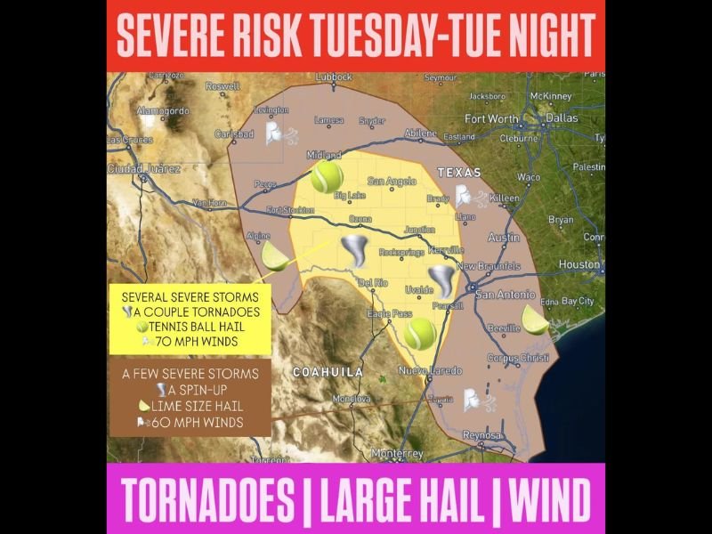
SAN ANGELO, TX — A significant severe weather risk is forecast for West and Central Texas on Tuesday through Tuesday night, with the primary threat zone covering a broad yellow highlighted corridor from the Midland and Big Lake area southward through Ozona, Junction, Del Rio, and Uvalde. The yellow zone carries the most extreme hazards, including tennis ball sized hail, a couple of tornadoes, and wind gusts reaching 70 miles per hour, while the surrounding brown outer zone from Lubbock and Abilene southward through the Trans-Pecos region faces a few severe storms, lime size hail, a possible spin-up tornado, and 60 mph winds.
Yellow Zone Faces Tennis Ball Hail Tornadoes and 70 MPH Winds Tuesday and Tuesday Night
The highest risk zone on Tuesday’s severe weather outlook covers a concentrated area across west and central Texas, with the most extreme hazard set including tennis ball sized hail measuring approximately 2.5 inches in diameter, a couple of tornadoes, and destructive wind gusts reaching 70 miles per hour. Communities across Midland, Big Lake, San Angelo, Ozona, Rocksprings, Junction, Kerrville, Del Rio, Uvalde, and Pearsall all fall within or near this highest risk corridor as the Tuesday severe weather setup develops through the afternoon and overnight hours.
Tennis ball sized hail at these dimensions is capable of causing catastrophic damage to vehicles, roofing, and any unprotected property across the affected zone, while 70 mph wind gusts will down trees and power lines across the open west Texas landscape.
Brown Outer Zone Covers Lubbock Through the Trans-Pecos With Lime Size Hail and 60 MPH Winds
The broader outer risk zone covering the brown shaded area from Lubbock and Carlsbad southward through Fort Stockton, Alpine, and toward the Texas-Mexico border region carries a few severe storms, lime size hail, a possible tornado spin-up, and 60 mph winds. While the hazard profile in this zone is slightly less extreme than the yellow corridor, the threat remains serious and demands the same level of preparation and weather awareness from all residents across the outer risk area through Tuesday and Tuesday night.
West and Central Texas Residents Urged to Prepare Now Before Tuesday Storms Arrive
All residents across both the yellow and brown severe risk zones from Lubbock and Midland southward through Del Rio and Corpus Christi are strongly urged to prepare their severe weather plans, identify shelter locations, and monitor updated forecasts closely as Tuesday’s dangerous storm potential develops across west and central Texas.
For continuing coverage of severe weather risks and storm forecasts across the United States, visit SaludaStandard-Sentinel.com.