Significant Rainfall Totals of 2 to 3 Inches Recorded Across New Jersey and Pennsylvania Monday Evening Offering Critical Relief to a Region 15 Inches Behind in Yearly Rainfall
TRENTON, NJ — A meaningful and much needed rainfall event is delivering significant precipitation across New Jersey, Pennsylvania, and surrounding Mid-Atlantic communities as of Monday at 8:30 PM, with recorded totals ranging from 1 to 3.6 inches across the region. The rainfall comes as a critical development for an area currently running 15 inches behind in precipitation over the past 12 months, with the next four days of continued rain chances offering the best opportunity for meaningful drought deficit recovery the region has seen in recent months.
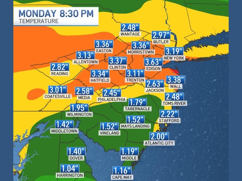
Rainfall Totals of 3 to 3.6 Inches Recorded Across Central New Jersey and Eastern Pennsylvania
The heaviest recorded rainfall totals through Monday evening are concentrated across central New Jersey and eastern Pennsylvania, with Clinton leading at 3.37 inches, followed closely by Morristown and Easton at 3.36 inches each. Hatfield recorded 3.34 inches, Allentown sits at 3.13 inches, and Edison recorded 3.63 inches as some of the highest individual totals across the region through the 8:30 PM observation window.
New York recorded 3.19 inches through the same period, while Butler reached 2.97 inches and Wall recorded 3.38 inches, reflecting the broad geographic distribution of significant rainfall totals across the greater New Jersey and eastern Pennsylvania corridor.
Southern New Jersey and Delaware See Lighter but Still Meaningful Accumulations
Southern New Jersey and Delaware communities recorded comparatively lighter but still beneficial rainfall totals through Monday evening. Atlantic City recorded 2.00 inches, Toms River reached 2.48 inches, and Stafford recorded 2.22 inches across the southern Jersey Shore corridor. Delaware communities including Dover recorded 1.40 inches, Harrington 1.04 inches, and Wilmington 1.95 inches, while Cape May and Middle recorded totals of 1.16 and 1.19 inches respectively through the observation period.
Baltimore recorded 2.15 inches through the same window, extending the meaningful rainfall footprint southward into the Maryland portion of the Mid-Atlantic region.
Four More Days of Rain Chances Offer Best Hope for Drought Recovery in Months
With the region running a staggering 15 inches behind normal precipitation over the past 12 months, Monday evening’s rainfall represents only a partial but welcome step toward addressing the significant drought deficit across New Jersey, Pennsylvania, and surrounding states. The next four days of continued rain chances offer the most promising consecutive stretch of precipitation opportunity the drought stricken region has seen recently, with forecasters indicating the extended wet pattern could deliver meaningful additional accumulations across the Mid-Atlantic through the remainder of the week.
For continuing coverage of rainfall totals and drought recovery across the United States, visit SaludaStandard-Sentinel.com.