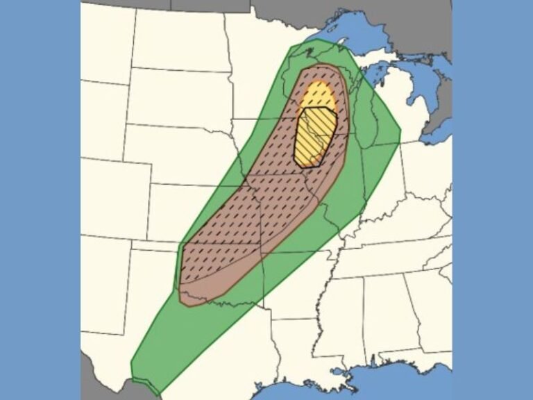
Strong to Locally Severe Morning Storms With 40 MPH Gusts Sweep Across Illinois Monday May 18 With Temps Reaching Mid 80s Statewide After Storms Clear
SPRINGFIELD, IL — A strong to locally severe morning storm system is sweeping across Illinois on Monday, May 18, 2026, impacting different regions of the state at staggered timeframes throughout the morning hours before giving way to warm, muggy, and mostly dry afternoon conditions across the majority of the state. Behind the departing storms, gusty winds reaching up to 40 miles per hour are expected statewide, with southern Illinois remaining wet well into the afternoon before eventually drying out later in the day.
Morning Storm Timeline Varies by Region From Midnight Through Early Afternoon
Northwest Illinois is bearing the brunt of the storm activity earliest, with the impact window running from midnight through 6:00 AM. Northeast Illinois follows with storms expected between 3:00 AM and 9:00 AM, while central Illinois sees its storm window running from 3:00 AM through noon. Southern Illinois faces the latest and most extended storm window, with activity persisting from noon through 6:00 PM, keeping that region wet significantly longer than the rest of the state.
These storms carry the potential to be strong to locally severe, with the primary hazard being strong winds capable of causing localized damage across affected communities during each region’s respective storm window.
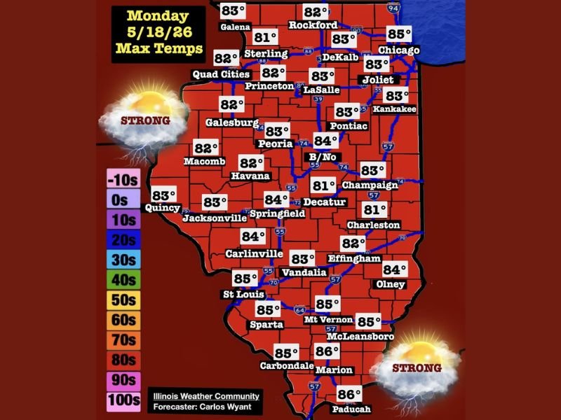
Temperatures Surge Into the Mid 80s Statewide as Storms Clear Through the Day
Monday’s maximum temperature forecast shows widespread mid 80s developing across Illinois as storm activity clears and afternoon sunshine returns to most of the state. Southern communities including Marion, Paducah, and Carbondale are forecast to reach 86 degrees, while the St. Louis corridor, Mt. Vernon, McLeansboro, and Sparta are projected at 85 degrees through the afternoon hours.
Central Illinois communities including Springfield, Decatur, Peoria, and Carlinville are forecast in the 83 to 84 degree range, while northern communities from Chicago and Rockford through the Quad Cities sit in the lower 80s as afternoon temperatures climb statewide behind the departing morning storm system.
Evening Brings New Storm Cluster Developing in Iowa and Pushing East Overnight
As Monday evening arrives and the morning storm system fully clears Illinois, attention turns to the next weather maker as a new storm cluster developing in Iowa is expected to push eastward overnight. This additional storm system will require continued weather awareness through the overnight hours for communities across northern and central Illinois as the active late spring pattern shows no signs of settling down heading into the new week.
For continuing coverage of storm forecasts and severe weather tracking across the United States, visit SaludaStandard-Sentinel.com.