Incredibly Powerful Debris Filled Tornado With Rare Angry Octopus Vortex Structure Strikes Near Saint Libory Nebraska Before Intense Storms Spread Into Iowa
SAINT LIBORY, NE — An incredibly powerful and rapidly intensifying tornado developed near Saint Libory, Nebraska, displaying rare and extreme meteorological characteristics that placed it among the most violent tornado observations of the current severe weather season. The debris filled tornado exhibited tentacle-like horizontal vortex rolls orbiting around its core, a phenomenon known among storm chasers as the Angry Octopus phase, typically observed only in the most violent tornado events and indicative of exceptionally intense upward velocities within the circulation.
Rare Angry Octopus Vortex Structure Signals Extreme Tornado Intensity Near Saint Libory
The horizontal vortex rolls observed orbiting around the Saint Libory tornado represent one of the rarest and most visually dramatic structural features ever documented in tornado observation. This Angry Octopus configuration is considered by meteorologists and experienced storm chasers to be a hallmark of violent tornado intensity, appearing only when upward velocities within the vortex reach extreme levels capable of generating these distinctive tentacle-like appendages around the main circulation.
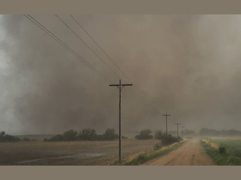
Photographic documentation of the tornado shows an enormous debris filled circulation consuming the landscape along a rural Nebraska road, with a thick dark debris cloud extending across the entire field of view and visibility reduced to near zero beneath the tornado’s immediate path.
Tornado Remained Short Lived Despite Its Extreme Intensity and Violent Structure
Despite the exceptional violence of the Saint Libory tornado’s structure and the extreme intensity suggested by its Angry Octopus vortex characteristics, the tornado remained on the ground for less than ten minutes before dissipating. Tornadoes exhibiting this level of structural intensity would typically be expected to remain on the ground for 20 or more minutes, making the relatively short lifespan of this particular storm a fortunate outcome given the extreme destructive potential it displayed during its brief but violent touchdown near Saint Libory.
The tornado passed very close to documented observer positions during its track, with the debris filled circulation moving at a fast forward speed that left minimal margin for repositioning along muddy rural access roads near cornfields in the storm’s immediate path.
Widespread Intense Storms Spread Across Nebraska and Move Into Iowa
Beyond the Saint Libory tornado event, widespread intense storms developed across Nebraska during the same active severe weather period and subsequently moved eastward into Iowa, extending the significant storm threat across a broad multi-state corridor. The continuation of this active storm pattern into Iowa means residents across both states faced ongoing severe weather hazards well into the overnight hours following the Saint Libory tornado event.
Communities across Nebraska and Iowa are urged to remain weather aware as the intense storm activity continues across the region, with another significant severe weather day forecast to follow in the same general areas in the coming day.
For continuing coverage of tornado events and severe storm tracking across the United States, visit SaludaStandard-Sentinel.com.