Intense Severe Thunderstorms With Tornadoes Very Large Hail and Damaging Winds Targeting Iowa Nebraska Kansas and South Dakota Sunday Through Sunday Night as All-Hazard Risk Develops
DES MOINES, IA — Significant and intense severe thunderstorms are probable across a broad multi-state corridor Sunday afternoon through Sunday night, with the highest confidence of the most intense storm activity focused across Iowa, Minnesota, South Dakota, Kansas, and Nebraska, where any matured supercell or storm cluster will carry an all-hazard severe weather risk including tornadoes, very large hail, and damaging wind gusts.
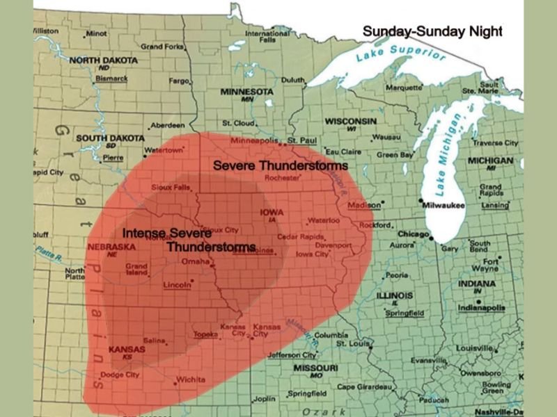
Intense Severe Thunderstorms Most Likely Across Five State Core
The innermost and most dangerous threat zone on Sunday’s severe weather outlook map is centered across Nebraska, Iowa, and Kansas, where intense severe thunderstorm potential is highlighted in the deepest red shading covering the region. This core zone represents the area of highest atmospheric energy, best wind shear, and greatest confidence for significant supercell thunderstorm development during the Sunday afternoon and evening hours.
Confidence is highest across Iowa, Minnesota, South Dakota, Kansas, and Nebraska for producing the most intense storms of the event, with the triple-point boundary expected to serve as the primary initiation zone for organized convection by early evening Sunday.
All-Hazard Risk Including Tornadoes and Very Large Hail
Any supercell or storm cluster that fully matures during Sunday’s event will carry a complete all-hazard severe weather risk across the affected corridor. Tornadoes, very large hail, and damaging wind gusts are all simultaneously possible with the most intense storms, reflecting the highly favorable atmospheric environment developing across the central plains and upper Midwest for significant severe weather production during the Sunday timeframe.
The shortwave trough overspreading the region combined with increasing height falls will provide the dynamic forcing necessary to support explosive and sustained severe thunderstorm development across the core threat zone during the afternoon and evening hours.
Broader Severe Thunderstorm Zone Extends Into Illinois and Missouri
Beyond the intense core zone, a broader severe thunderstorm threat zone extends across portions of Minnesota, Wisconsin, Illinois, and Missouri, where severe thunderstorms are possible though with somewhat lower confidence compared to the core five-state area. Storm development further south carries additional uncertainty depending on whether convection initiates successfully in the warm sector ahead of the advancing trough boundary during the Sunday afternoon heating hours.
Residents across all states within both the intense and broader severe weather zones are urged to have shelter plans ready and weather alert systems active throughout Sunday afternoon and evening. For continuing coverage of severe weather events and critical storm analysis across the United States, visit SaludaStandard-Sentinel.com.