50 to 60 MPH Wind Gusts and Hail Targeting Illinois and Indiana Tonight as Fast Moving Storms Track From Canton and Chicago Through Bloomington and Fort Wayne Between 9 PM and Midnight
CHICAGO, IL — Storms carrying 50 to 60 mile per hour wind gusts and hail are forming on the backside of widespread rainfall moving through Illinois and Indiana as of 9 PM ET on May 12, 2026, tracking eastward at 45 miles per hour and delivering a precisely timed arrival sequence from Canton and the Chicago area through Bloomington, Decatur, and into Fort Wayne before midnight.
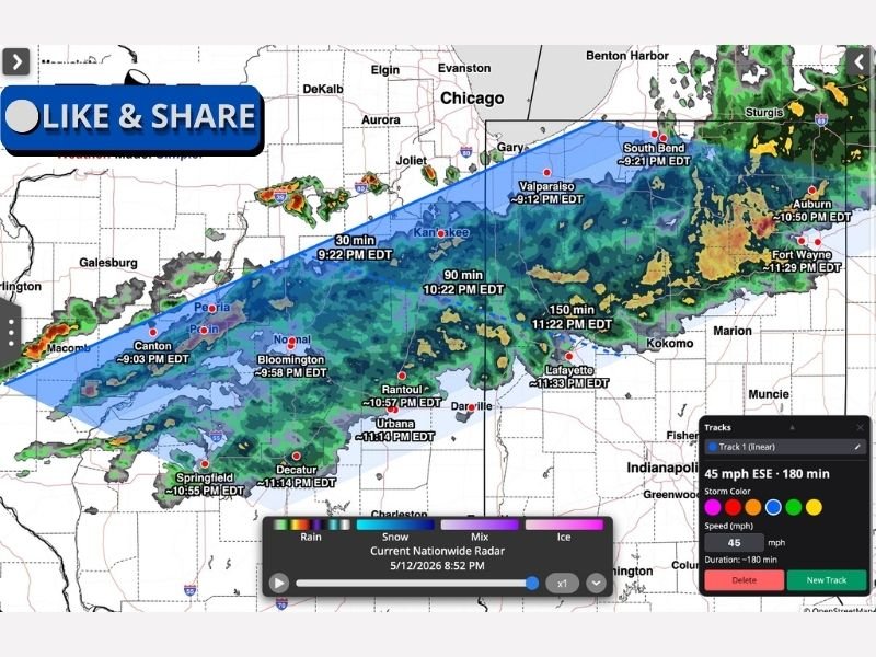
Storms Forming on Backside of Rain System at 9 PM
The developing storm threat is originating on the trailing edge of a broad rainfall system already moving through Illinois and Indiana, with new storm development firing along the backside of the moisture shield as of the 8:52 PM radar update. The storms are tracking at 45 miles per hour in an east-southeastward direction, meaning communities across the Illinois and Indiana corridor will experience the arriving storm activity in rapid succession through the evening hours.
Wind gusts of 50 to 60 miles per hour accompanying these storms are capable of downing trees, snapping utility lines, and causing structural damage across communities in the direct storm path during the overnight hours.
Precise Arrival Times Mapped Across Illinois and Indiana
Storm Tracker data provides specific arrival timing for communities across the affected corridor. Canton is first at approximately 9:03 PM, followed by the Kankakee area at 9:22 PM and Valparaiso at 9:12 PM. Bloomington arrives at approximately 9:58 PM, with South Bend at 9:21 PM and Gary slightly later.
Further east, Rantoul sees storms around 10:57 PM, Urbana and Decatur at approximately 11:14 PM, Springfield at 10:55 PM, Lafayette at 11:33 PM, and Fort Wayne at approximately 11:29 PM as the fast-moving system continues its eastward progression through the region.
Residents Must Act Ahead of Arrival Times
With storms moving at 45 miles per hour, the window between initial awareness and storm arrival is extremely compressed for communities across the Illinois and Indiana corridor. Residents in each affected community should seek shelter in a sturdy interior location well ahead of their specific estimated arrival time, secure any outdoor items capable of becoming projectiles in 60 mph wind gusts, and keep weather alert systems active throughout the evening hours.
For continuing coverage of severe weather events and critical storm analysis across the United States, visit SaludaStandard-Sentinel.com.