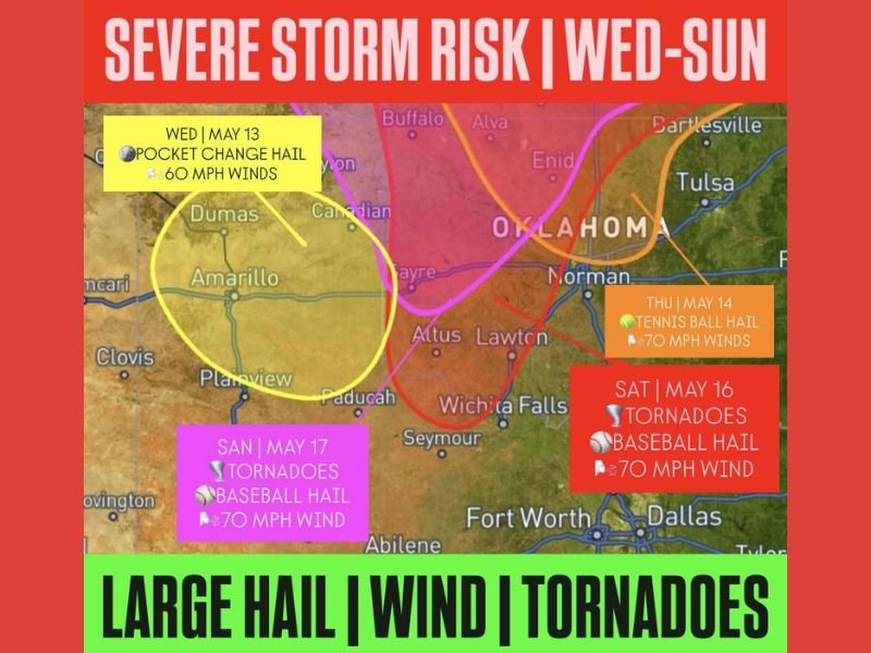
Tornadoes Baseball Hail and 70 MPH Winds to Escalate Across Oklahoma and North Texas From Wednesday Through Sunday as High-Impact Severe Weather Weekend Looms May 16 and 17
OKLAHOMA CITY, OK — A multi-day severe weather outbreak is set to escalate across Oklahoma and parts of North Texas from Wednesday May 13 through Sunday May 17, with threats intensifying from small hail and 60 mph winds on Wednesday to tennis ball size hail and 70 mph winds Thursday, before the weekend delivers tornadoes, baseball size hail, and 70 mph wind gusts on both Saturday and Sunday in what forecasters describe as a particularly favorable setup for high-impact severe weather.
Wednesday Kicks Off Multi-Day Severe Weather Stretch
The severe weather stretch begins Wednesday May 13 with the lowest-tier threat of the extended outbreak, bringing small coin-size hail and 60 mph wind gusts across the Amarillo and Texas Panhandle corridor. While Wednesday represents the least intense day of the multi-day sequence, it signals the beginning of a sustained and escalating severe weather pattern across the region that will intensify considerably through the remainder of the week.
Residents across the Amarillo, Plainview, and surrounding Panhandle communities should treat Wednesday as the opening round of a week that demands continuous weather awareness.
Thursday Escalates to Tennis Ball Hail and 70 MPH Winds
Thursday May 14 delivers a significant escalation in threat level, with tennis ball size hail and 70 mph wind gusts targeting the Oklahoma and North Texas corridor including the Norman, Lawton, and Wichita Falls area. Tennis ball hail measuring approximately 2.5 inches is capable of catastrophically damaging vehicles and structures, while 70 mph winds represent near-destructive force across any community in the storm’s direct path.
The Thursday threat zone shifts the primary risk eastward toward more populated Oklahoma communities compared to Wednesday’s Panhandle-focused activity.
Weekend Brings Tornadoes and Baseball Hail Saturday and Sunday
The most dangerous period of the entire multi-day sequence arrives Saturday May 16 and Sunday May 17, when both days carry explicit tornado threats alongside baseball size hail and 70 mph wind gusts across Oklahoma and North Texas. The back-to-back nature of significant tornado-capable setups across consecutive weekend days represents an extraordinary and dangerous severe weather scenario for the region.
All residents across Oklahoma and North Texas are urged to finalize shelter plans well before the weekend arrives and maintain continuous weather awareness from Wednesday through Sunday.
For continuing coverage of severe weather events and critical storm analysis across the United States, visit SaludaStandard-Sentinel.com.