Late Night Storm Line to Enter Western Arkansas Between 3 and 5 AM Sunday With Heavy Rain Thunder and Low Severe Risk Tracking Southeast Through Fort Smith and Texarkana Ahead of Mothers Day
FORT SMITH, AR — A line of storms is forecast to enter western Arkansas between 3 and 5 AM Sunday morning, bringing heavy rain, thunder, and a very low but nonzero severe weather risk to the western and southwestern sections of the state as the system tracks southeastward through the overnight hours, with scattered rain chances potentially lingering into Mother’s Day Sunday across portions of Arkansas.
Storm Line Arriving Between 3 and 5 AM
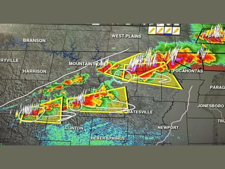
Forecast data that evolved through the day has shifted the overnight storm timing, with the storm line now expected to push into western Arkansas during the 3 to 5 AM window. The Arkansas Weather Network Futurecast valid for Sunday 4:00 AM shows the most intense storm activity concentrated across the Fayetteville, Fort Smith, Mena, De Queen, and Texarkana corridor, with the heaviest precipitation returns clustered along the western and southwestern border of the state at that time.
The line will continue tracking southeastward as the overnight hours progress, gradually advancing the rainfall and storm activity toward central Arkansas communities including Russellville and Little Rock before the morning hours arrive.
Western and Southwestern Arkansas Face Best Storm Chances
The western and southwestern sections of Arkansas carry the highest probability of overnight storm activity, sitting directly in the path of the incoming line as it crosses the state border during the early morning hours. Communities including Fayetteville, Fort Smith, Mena, and Texarkana will be among the first to experience the arriving storms, with the line then spreading gradually eastward and southeastward through the remainder of the overnight period.
Eastern Arkansas communities including Jonesboro, Batesville, and Helena face considerably lower overnight storm chances, with the primary activity expected to remain concentrated across the western half of the state through the early morning hours.
Severe Risk Very Low but Heavy Rain and Thunder Expected
While a severe weather risk exists overnight, forecasters are clear that the threat level is very low, with perhaps some stronger wind gusts representing the most likely outcome from the most intense cells within the line. The more widespread and certain impact will be heavy rain and thunder capable of waking residents across western Arkansas during the overnight hours as the storm line pushes through the region between 3 and 5 AM.
Residents across the western and southwestern portions of the state should ensure weather alert systems remain active through the overnight period to receive any warning upgrades should conditions intensify beyond current expectations.
Scattered Rain Possible for Mothers Day Sunday
Following the overnight storm passage, the atmosphere may not fully clear before scattered rain and storm chances return for Mother’s Day Sunday across Arkansas. While rain chances for the holiday are not particularly impressive, the possibility of additional showers and storms during the day means outdoor Mother’s Day plans across the state should include contingency options through the afternoon hours.
For continuing coverage of severe weather events and critical storm analysis across the United States, visit SaludaStandard-Sentinel.com.