Storms Developing Across Collin and Hunt Counties Texas With Small Hail and Gusty Winds Possible as Intense Cells Pop Near Leonard Greenville and Sulphur Springs
GREENVILLE, TX — Storms are actively developing across Collin and Hunt counties in North Texas, with small hail and gusty winds both possible as the most intense cells organize along a corridor stretching from Leonard through Greenville and eastward toward Sulphur Springs, while broader rainfall coverage extends across the Dallas, Plano, and surrounding metropolitan areas simultaneously.
Storms Popping Across Collin and Hunt Counties
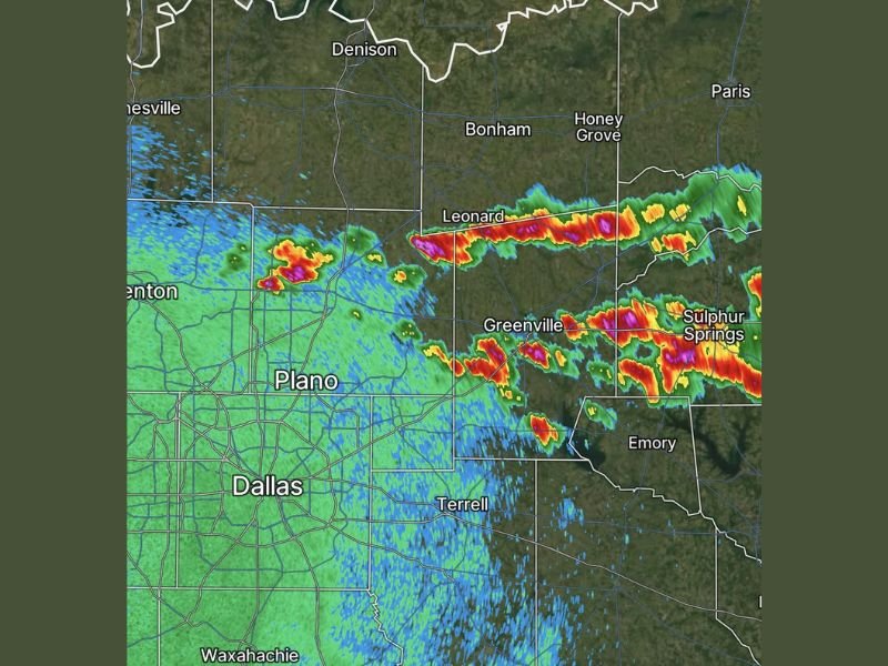
Radar imagery shows active storm development concentrated across Collin and Hunt counties, with the strongest returns aligned in a distinct band tracking through the Leonard and Greenville area. The storm cells producing the most intense radar signatures are positioned across Hunt County in particular, where the deepest reds and purples on radar indicate heavy precipitation cores within the developing convection moving through the region.
The broader storm environment across the DFW northeastern corridor is active, with multiple cells at varying stages of development visible across the radar frame from Denton and Plano eastward through Collin and Hunt counties toward Sulphur Springs.
Small Hail and Gusty Winds the Primary Concerns
The primary hazards associated with the developing Collin and Hunt county storms are small hail and gusty winds, both of which can accompany even non-severe thunderstorm cells during periods of active convection across North Texas.
While the threat level does not currently rise to the level of a severe thunderstorm warning, small hail is capable of causing minor damage to vehicles and outdoor property, and gusty winds accompanying the heavier cells could create brief and localized hazardous conditions across the affected counties.
Residents in Collin and Hunt counties should be aware of the developing storm activity and prepared to take precautions if conditions intensify in their immediate vicinity.
Intense Radar Returns From Leonard Through Sulphur Springs
The most significant storm activity on radar is concentrated along a northeast-oriented band extending from Leonard through Greenville and continuing eastward toward Sulphur Springs, where extremely intense radar returns indicate heavy rainfall and the strongest storm cores within the current convective episode. This corridor represents the highest probability zone for small hail and gusty wind occurrence as the storms continue developing and moving through the region.
Communities along and near this band including Bonham, Honey Grove, and Emory should also remain attentive to conditions as the storm line evolves through the afternoon and evening hours across northeast Texas.
For continuing coverage of severe weather events and critical storm analysis across the United States, visit SaludaStandard-Sentinel.com.