Isolated Severe Storms With 50 MPH Wind Gusts to Track From Baltimore Through Philadelphia and Trenton Into New York Between 3 and 7 PM Saturday Afternoon
PHILADELPHIA, PA — Isolated severe thunderstorms carrying wind gusts up to 50 miles per hour are forecast to push through a corridor stretching from Baltimore and Dover northward through Philadelphia, Wilmington, Trenton, and into the New York metro area between 3 and 7 PM Saturday afternoon, though forecasters are emphatic that the threat remains isolated in nature rather than representing a widespread or organized severe weather outbreak across the region.
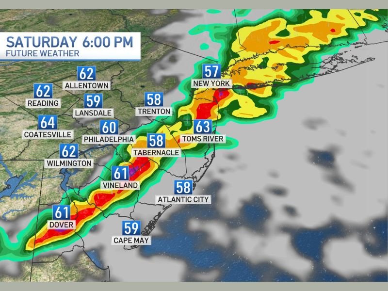
Isolated Severe Storm Window Between 3 and 7 PM
The Saturday afternoon severe weather window is narrow and well-defined, with the primary threat period running from approximately 3 PM through 7 PM as the storm line advances northeastward through the Mid-Atlantic corridor. Future Weather imagery valid for Saturday 6:00 PM shows a distinct storm band with intense radar returns concentrated along a line from Dover and Vineland through Philadelphia and Wilmington and extending northeastward toward Trenton, Toms River, and the New York metropolitan area.
The isolated nature of the threat means that not every community within the broader corridor will experience severe weather, with the most intense cells impacting specific locations along the storm track rather than producing uniform coverage across the entire region.
Wind Gusts to 50 MPH the Primary Concern
The dominant hazard associated with Saturday’s isolated severe storm threat is wind gusts reaching up to 50 miles per hour, capable of downing tree branches, scattering unsecured outdoor items, and causing localized power outages across communities directly impacted by the strongest cells moving through the corridor. While 50 mph gusts fall at the lower end of the severe thunderstorm wind threshold, they remain capable of producing meaningful damage particularly in areas with significant tree canopy or overhead utility lines.
Residents with outdoor plans across Baltimore, Philadelphia, Wilmington, and the New York area should be prepared to move indoors quickly if storms approach during the Saturday afternoon timeframe.
Storm Line Tracking From Baltimore to New York
The forecast storm track runs in a well-organized northeast orientation, advancing from the Baltimore and Dover area through the heart of the Delaware Valley including Philadelphia, Coatesville, and Wilmington before pushing into central New Jersey communities including Trenton, Tabernacle, Vineland, and Toms River, and ultimately reaching the New York metropolitan area by the latter portion of the 3 to 7 PM window.
Temperatures across the corridor will range from the upper 50s to the mid 60s during the storm passage, consistent with the cooler airmass in place across the Northeast for the weekend period.
For continuing coverage of severe weather events and critical storm analysis across the United States, visit SaludaStandard-Sentinel.com.