Weakening Storm Line With Gusty Winds Heavy Rain and Lightning Moves Through Northern Indiana as Outflow Boundary Becomes Dominant Across South Bend, Kokomo, and Indianapolis Corridor
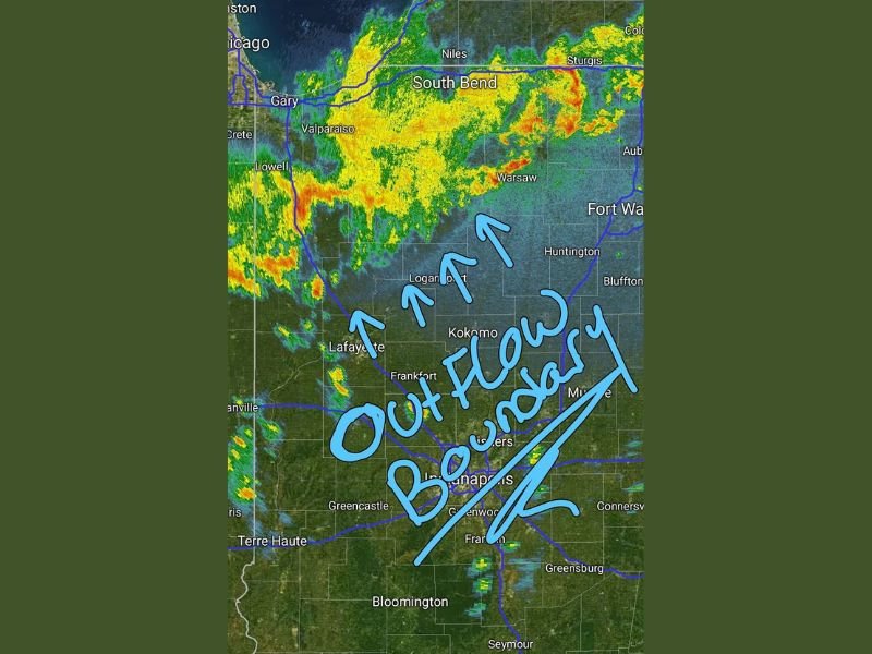
INDIANA — A line of stronger thunderstorms riding an encroaching cold front across northern Indiana was showing clear signs of weakening during the late night hours, transitioning to outflow-dominant storm mode with a prominent outflow boundary visible on radar stretching from the South Bend and Warsaw corridor southward through Kokomo, Logansport, Lafayette, and Indianapolis as the system gradually wound down.
Radar imagery showed the storm complex maintaining active precipitation coverage across northern Indiana from the Chicago and Gary area through South Bend, Valparaiso, Niles, and Warsaw, with the outflow boundary pushing southward into the central Indiana corridor and signaling the diminishing severe potential of the weakening system.
Severe Threat Drops to Very Low Levels
While the storm line was still producing gusty winds, heavy rain, small hail, and frequent lightning across the affected communities, the overall severe weather threat had dropped to extremely low levels as the system became outflow dominant and lost the organized rotational characteristics necessary for significant severe storm development.
A few cells across central and southern Indiana retained some overachiever potential, but the broader severe weather environment was no longer supportive of widespread or intense severe storm activity across the Indiana corridor through the remainder of the overnight hours.
Storms Expected to Wind Down Over Next Few Hours
The outflow-dominant structure visible on radar confirmed that the storm line was in its final stages of activity across Indiana, with the system expected to gradually run out of energy and wind down over the next few hours as the cold front pushed through the region. The prominent outflow boundary stretching through the Indianapolis, Greenwood, and Greensburg corridor marked the forward edge of the dying storm system’s influence across central Indiana.
Residents across the South Bend, Kokomo, Indianapolis, and surrounding Indiana communities were advised to maintain active weather alerts through the overnight hours as a precaution, though conditions were expected to improve steadily as the weakening storm line pushed eastward and dissipated.
For continuing coverage of severe weather events and critical storm analysis across the United States, visit SaludaStandard-Sentinel.com.