Heavy Rain Event Brings Half to One Inch Rainfall Across North and Central Alabama From Friday Night Through Saturday Sunrise Targeting Birmingham, Tuscaloosa, Montgomery, and Huntsville
BIRMINGHAM, AL — A widespread rain event was forecast to sweep across North and Central Alabama beginning Friday afternoon and intensifying through Friday night into Saturday sunrise, delivering half an inch to one inch of rainfall across communities near and south of Interstate 20 with no severe weather threat accompanying the system across the region.
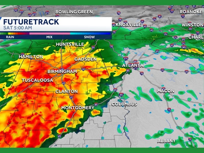
FutureCast imagery valid at 5:00 AM Saturday showed intense precipitation coverage blanketing a broad stretch of Alabama from Tuscaloosa and Birmingham southward through Clanton, Montgomery, and beyond, with the heaviest rainfall concentrated across the I-20 corridor and southern communities through the overnight hours.
Heaviest Rain Falls Near and South of Interstate 20
The most significant rainfall accumulations of half an inch to one inch were forecast for communities near and south of Interstate 20, covering Tuscaloosa, Birmingham, Shelby County, Pell City, Clanton, Anniston, Talladega, Montgomery, Auburn, and Selma. This corridor represented the primary rainfall zone for the Friday night through Saturday sunrise event, with the overnight hours delivering the best rain and thunder across the region.
Despite the active overnight precipitation, no severe weather threat was anticipated across North and Central Alabama with this system, keeping the event within the category of a beneficial and non-threatening rainfall event for the affected communities.
Northern Alabama Sees Lighter Accumulations
Communities north of the Interstate 20 corridor were forecast to receive lighter rainfall accumulations ranging from one-tenth to half an inch during the event. Jasper, Cullman, Gadsden, Centre, and Oneonta fell within this lighter rainfall zone, with amounts staying below the more significant totals expected further south.
Further north across the Tennessee Valley corridor, higher rainfall amounts were expected across Huntsville, Decatur, The Shoals, Fort Payne, Albertville, Guntersville, and Scottsboro, where forecast totals were projected to run considerably higher than the intermediate zone communities positioned between the two primary rainfall corridors.
Sun Returns by Saturday Afternoon
Following the Friday night through Saturday sunrise rain event, clearing conditions were expected to develop across Alabama through Saturday morning with sunshine returning to the region by Saturday afternoon. The brief but welcome rainfall event was set to give way to improving conditions relatively quickly, providing communities across North and Central Alabama with a pleasant end to the weekend following the overnight precipitation.
Residents across Birmingham, Tuscaloosa, Montgomery, and surrounding communities were advised to anticipate wet road conditions through the Friday night and early Saturday morning hours before conditions improved heading into the afternoon.
For continuing coverage of weather events and critical storm analysis across the United States, visit SaludaStandard-Sentinel.com.