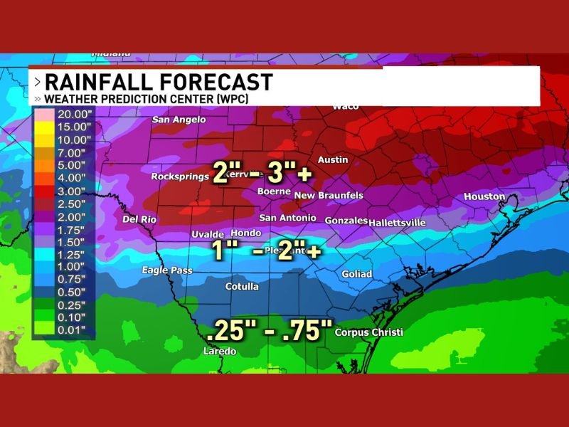
Major Soaking Rain Event With Thunderstorm Downpours Targets Central Texas With 2 to 3 Plus Inches Forecast Across San Antonio, Austin, New Braunfels, and Boerne Thursday Night Through Friday
SAN ANTONIO, TX — A significant and widespread rainfall event was shaping up to deliver a major soaking across central Texas from Thursday night through Friday, with Weather Prediction Center rainfall forecast data showing 2 to 3 plus inches of precipitation expected across the San Antonio, Austin, New Braunfels, Boerne, and Kerrville corridor during the primary rain window.
The Thursday night into Friday timeframe was identified as the main window for the highest rainfall chances, with thunderstorm downpours adding the potential for localized rainfall totals to surge well above forecast averages across communities positioned within the core of the heaviest precipitation zone.
Heaviest Rainfall Concentrated Across Central Texas Corridor
Weather Prediction Center forecast data showed the heaviest rainfall accumulations concentrated across a broad central Texas corridor stretching from Rocksprings and Kerrville eastward through Boerne, New Braunfels, San Antonio, Gonzales, and Hallettsville. Rainfall totals of 2 to 3 plus inches were depicted across this primary zone, with the deep red and purple colors on the forecast map confirming the significant precipitation potential heading into the Thursday night and Friday timeframe.
Areas further north toward Austin and Waco fell within an even higher rainfall zone on the WPC forecast map, with totals potentially reaching 5 inches or greater across portions of the northern central Texas region depending on thunderstorm placement and intensity through the event.
Southern Texas Sees Lighter but Meaningful Accumulations
Communities across southern Texas including Uvalde, Hondo, and Pleasanton were forecast to receive between 1 and 2 plus inches of rainfall during the event, representing a meaningful but lesser accumulation compared to the heavier totals expected further north across the central Texas corridor.
Further south toward Laredo, Cotulla, and Corpus Christi, rainfall totals were forecast in the quarter inch to three-quarter inch range, reflecting the diminishing precipitation gradient across the southernmost portions of Texas within the WPC forecast area.
Thunderstorm Downpours Add Flash Flood Consideration
The presence of thunderstorm downpours within the broader rainfall event raised flash flooding as a consideration for communities across central Texas through the Thursday night and Friday window. Thunderstorm-driven rainfall can concentrate extremely high accumulations over short periods, overwhelming drainage systems and creating rapidly developing flood conditions even in areas where total forecast accumulations appear moderate.
Residents across San Antonio, New Braunfels, Boerne, Austin, and surrounding central Texas communities were advised to monitor updated rainfall forecasts closely as the Thursday night event approached and remain alert for any flash flood watches or warnings issued across the region.
For continuing coverage of weather events and critical storm analysis across the United States, visit SaludaStandard-Sentinel.com.