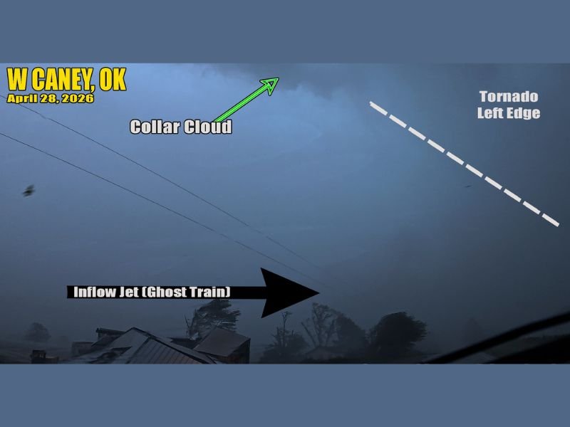
Rain-Wrapped Tornado Completely Buried in Precipitation Near Caney, Oklahoma on April 28, 2026 Reveals Dangerous Collar Cloud and Inflow Jet Hidden From Plain Sight
CANEY, OK — A large and dangerous tornado near Caney, Oklahoma on April 28, 2026 demonstrated one of the most deadly and deceptive characteristics a tornado can possess — complete rain wrapping that buried the entire circulation within heavy precipitation, rendering it nearly invisible to anyone without trained eyes and expert knowledge of atmospheric signatures.
The tornado was completely wrapped in rain and tightly obscured from view, making its detection and identification extraordinarily difficult even for experienced observers navigating the area amid flying tree limbs, downed debris, and significant storm damage along tree-lined gravel roads surrounding the active tornado.
Collar Cloud and Inflow Jet Reveal What Rain Conceals
Despite the rain wrapping obscuring the visible funnel, several key atmospheric features captured in imagery taken near the tornado gave away its presence to trained observers. A collar cloud, also known as a tornado cyclone, was visible at the top of the frame above where the funnel would normally be seen, marking the upper circulation of the tornadic vortex extending above the rain-obscured lower portion.
At ground level, a powerful inflow jet was visible roaring directly into the tornado itself. This feature, nicknamed the ghost train by experienced storm chasers, represents the violent rush of low-level air being pulled horizontally into the base of the tornado circulation and serves as one of the clearest ground-level indicators of an active and powerful tornado even when the funnel itself remains completely hidden.
The Tornado Left Edge Slips Away in the Rain
Along the right side of the captured image, the possible outer left edge of the tornado itself was faintly visible, slipping in and out of view as the rain-wrapped circulation attempted to remain fully obscured. The barely perceptible edge of the tornado outline represented the only partial visual confirmation of the funnel structure beneath the heavy precipitation curtain surrounding the storm.
The combination of the collar cloud above, the ghost train inflow jet at ground level, and the faint tornado edge visible through the rain created a complete but deeply hidden picture of a large and active tornado moving through the Caney, Oklahoma area.
Tornadoes Do Not Always Look Like Textbook Funnels
The Caney tornado served as a critical and potentially life-saving reminder that tornadoes do not always present themselves as the easily identifiable funnel clouds commonly depicted in imagery. Tornadoes are defined as rotating winds extending from the cloud base to the ground and can take many different forms, with rain-wrapped circulations representing among the most dangerous precisely because they provide little to no visual warning to residents in their path.
A tornado buried entirely in rain can strike a community with virtually no visible warning, making reliable weather alert systems and early warning notifications the only meaningful line of defense for residents in areas where rain-wrapped tornadoes are possible.
For continuing coverage of severe weather events and critical storm analysis across the United States, visit SaludaStandard-Sentinel.com.