Strong Cold Front to Sweep Across the Central and Eastern United States Next Weekend Bringing 40-Degree Nights as Far South as the Gulf Coast Into Early May
CENTRAL AND EASTERN UNITED STATES — A strong cold front is being watched closely for the first weekend of May, with forecasters tracking the potential for one of the last significant cold pushes of the season to sweep across a broad stretch of the central and eastern United States. The cold front is expected to drag temperatures down considerably, with overnight lows potentially dipping into the 40s as far south as the Gulf Coast for a night or two following the frontal passage.
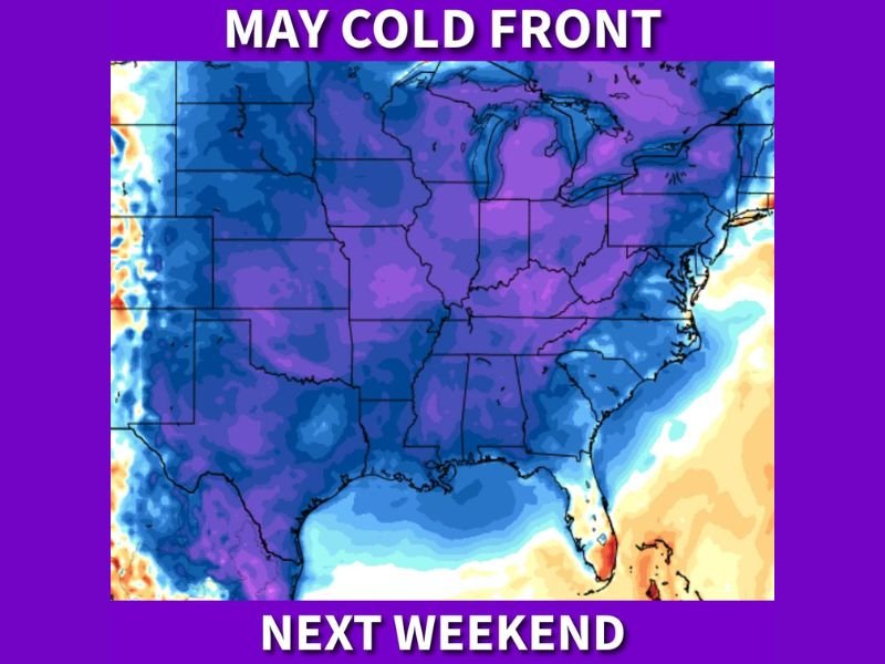
The temperature anomaly map associated with this system shows deep blue and purple shading blanketing nearly the entire central and eastern United States, indicating widespread below normal temperatures expected to follow the front’s arrival next weekend.
Widespread Cold Coverage Across Central and Eastern States
The coverage of cold air behind this front is impressive in scope. The temperature departure map shows below normal readings expected across virtually the entire region from the Plains through the Midwest, the South, and into the mid-Atlantic and Northeast.
States across the central corridor including Kansas, Missouri, Oklahoma, Arkansas, and Tennessee all fall deep within the cold air mass. The eastern seaboard from the Carolinas northward through Virginia, Maryland, and into New England is also blanketed by the cold signal, making this a coast-to-coast cold weather event for the eastern half of the country.
Gulf Coast Could See Overnight Lows in the 40s
One of the most notable aspects of this cold front is just how far south the chilly air is expected to penetrate. Forecasters are indicating that overnight temperatures could drop into the 40s along the Gulf Coast following the frontal passage, an unusually cold outcome for early May in that region.
For Gulf Coast communities in Louisiana, Mississippi, Alabama, and the Florida Panhandle, temperatures in the 40s during the first week of May are rare and worth noting for residents who may have already transitioned into warmer weather routines. Light jackets and extra layers will likely be needed on the coldest nights behind the front.
How Long the Cold Air Sticks Around
While the cold front is expected to bring a sharp temperature drop for next weekend, forecasters suggest the duration of the cold spell will be limited. The early May timing means that the atmosphere will be working quickly to moderate temperatures back toward seasonal norms following the frontal passage.
Forecasters are noting that this could be one of the last opportunities to experience genuinely cool and refreshing temperatures before summer heat begins building across the region in earnest. Residents are encouraged to enjoy the cooler conditions while they last, as the warmth of late spring and early summer will not be far behind.
Are you looking forward to the cool temperatures arriving with the May cold front next weekend? Share your thoughts and stay informed with the latest weather coverage at SaludaStandard-Sentinel.com.