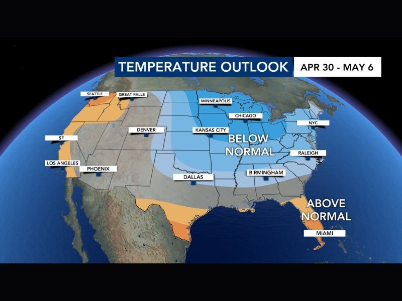
Below Normal Temperatures Expected Across Kansas, Dallas, Birmingham and Raleigh From April 30 Through May 6 With 30 to 40 Percent Chance of Cooler Than Average Conditions
CENTRAL UNITED STATES — The latest temperature outlook updated for the April 30 through May 6 period is showing a 30 to 40 percent chance of below normal temperatures across a broad stretch of the central and eastern United States as the calendar turns to May. The outlook covers a wide area including Kansas City, Dallas, Birmingham, Raleigh, Chicago, and New York City, signaling that the bigger heat many residents may have been anticipating heading into May is unlikely to materialize during this period.
Forecasters note that the normal high temperature for April 30 is 77 degrees with a normal low of 53 degrees. With below normal temperatures in the forecast, 90-degree readings are considered very unlikely across the affected region through the first week of May.
Below Normal Zone Stretches Across Central and Eastern States
The below normal temperature signal on the outlook map covers an expansive area of the country. Kansas City, Denver, Dallas, Minneapolis, Chicago, Birmingham, and Raleigh all fall within the below normal zone for the April 30 through May 6 window.
Further northeast, New York City also sits within the cooler than average signal, indicating that the below normal pattern is not limited to the central states but extends across much of the eastern seaboard as well. The breadth of the below normal zone suggests a well-established cooler air pattern will be in control across the majority of the country entering May.
Above Normal Signal Limited to Florida and the Southwest
While much of the central and eastern United States faces below normal temperatures, the above normal signal is confined to two much smaller areas on the outlook map. Miami and the southern tip of Florida remain in above normal territory, as do portions of the Pacific Southwest including the Los Angeles and Phoenix corridor.
Seattle and Great Falls in the Pacific Northwest also sit within a small above normal zone on the western edge of the map. For the vast majority of the country however, the dominant temperature story entering May is one of cooler than average conditions rather than early season heat.
What Below Normal Temperatures Mean for Early May
A below normal temperature designation does not guarantee cold or record-breaking low temperatures, but rather indicates that overall readings are more likely to run below historical averages for this time of year than above them. For residents across Kansas, Texas, Alabama, North Carolina, and surrounding states, this translates to a comfortable and mild start to May with little risk of oppressive heat during the first week of the month.
Forecasters are viewing the outlook positively, noting that the absence of 90-degree readings heading into early May is a welcome development for much of the region after recent periods of warmth.
Are you welcoming the cooler than normal temperatures heading into early May in your area? Share your thoughts and stay informed with the latest weather coverage at SaludaStandard-Sentinel.com.