GFS Model Projects Up to 10 Inches of Rainfall Across Tennessee, Kentucky, Missouri and Arkansas Over 16 Days Signaling a Major Pattern Shift That Could End the Southeast Drought
SOUTHEAST UNITED STATES — The latest midday GFS model run is painting an aggressive precipitation picture across the Southeast over the next 16 days, with some forecast totals reaching as high as 10 inches or more across portions of the region. Forecasters say the pattern is clearly shifting toward a much more active setup, raising the possibility that the prolonged drought gripping parts of the Southeast could finally begin to ease as rainfall chances increase starting this weekend and continuing into early May.
While forecasters caution that long-range model projections of this magnitude often settle down as the timeframe gets closer, the overall signal of a significant pattern change is considered credible and worth monitoring closely.
What the GFS Model Is Showing
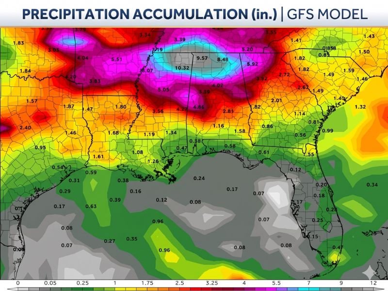
The midday GFS model run is showing some of the highest precipitation accumulation totals centered across the mid-South and portions of the central Southeast. The bullseye of heaviest projected rainfall sits across a corridor where totals of 9.57, 10.32, and 8.48 inches are being indicated over the 16-day window. Surrounding areas are forecast to receive anywhere from 3 to 6 inches across a broad swath, with totals of 5.51, 5.05, and 4.04 inches shown across adjacent portions of the region.
Further south and along the Gulf Coast, totals drop off considerably, with many areas projected to receive less than 1 inch during the same period. The contrast between the northern and southern portions of the forecast area is striking, with the heaviest rainfall clearly concentrated across the interior Southeast.
Drought Relief Possible but Long Range Uncertainty Remains
Forecasters are being transparent about the uncertainty surrounding these projections. Long-range model runs frequently produce aggressive precipitation bullseyes that tend to moderate as the actual event approaches. However, what meteorologists are confident about is the overall directional shift in the weather pattern, which is moving away from the dry and quiet conditions that have dominated the Southeast through much of April.
The combination of increasing storm chances, a more active atmospheric setup, and the potential for multiple rounds of rainfall over a 16-day period does present a genuine opportunity for meaningful drought improvement across parts of the region, even if the exact totals fall well short of what the current GFS model is projecting.
Active Storm Chances Beginning This Weekend
Beyond the long-range precipitation outlook, forecasters are highlighting the more immediate concern of an active storm pattern developing this weekend and continuing into early May. The shift toward a more unstable atmospheric setup means that alongside beneficial rainfall, there is also the potential for some strong storms to develop across portions of the Southeast starting as early as this weekend.
Residents across the region are encouraged to stay connected to updated forecasts as the weekend approaches, since storm timing and intensity details will become clearer in the coming days as the pattern begins to take shape.
Are you hoping for drought-ending rainfall across the Southeast, or are you tracking the upcoming storm chances heading into the weekend? Share your thoughts and stay informed with the latest weather coverage at SaludaStandard-Sentinel.com.