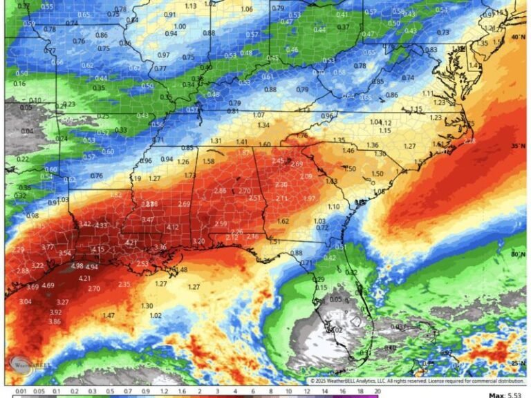
Alabama and Georgia Set to Receive Up to 4 Inches of Rain as Multiple Storm Systems Move Through the Region Saturday Through Tuesday
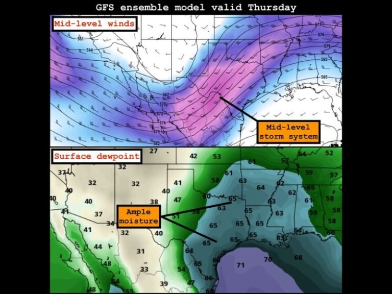
NORTH GEORGIA — A series of weather disturbances are projected to move through Alabama and North Georgia between Saturday and Tuesday, bringing potentially significant rainfall totals to a broad swath of the region. Forecasters are tracking multiple systems that, if they materialize as expected, could deliver anywhere from 1 to more than 4 inches of rain across parts of the area, raising concerns about runoff, localized flooding, and saturated ground conditions heading into next week.
The rainfall forecast varies considerably depending on location, with some of the heaviest totals anticipated across far northern Alabama and the foothills of North Georgia. Residents from Huntsville to Atlanta are being advised to monitor updated forecasts closely as the multi-day event unfolds.
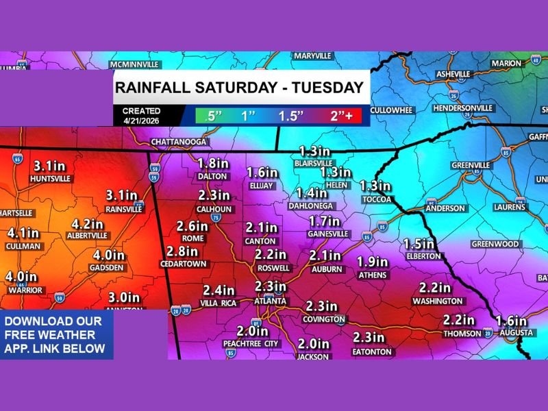
Heaviest Rainfall Totals Concentrated in Northern Alabama
According to the latest extended model data, the highest projected rainfall totals are expected across northern Alabama. Cullman is forecast to receive as much as 4.1 inches, while Albertville could see up to 4.2 inches. Gadsden and Warrior are each projected to receive approximately 4.0 inches, and both Huntsville and Rainsville are forecast near 3.1 inches, making the northern Alabama foothills the most at-risk zone across the entire multi-day event.
Warrior and Hartselle round out the Alabama totals with projected accumulations near 4.0 and 3.0 inches respectively, underscoring the widespread nature of the rainfall threat across the state’s northern tier.
Northwest Georgia Facing Significant Multi-Day Accumulation
In northwest Georgia, Cedartown leads local projections with an estimated 2.8 inches, followed by Rome at 2.6 inches and Calhoun at 2.3 inches. Dalton is forecast to receive around 1.8 inches, with Ellijay near 1.6 inches and Blairsville projected at approximately 1.3 inches.
Further south and east, Canton is forecast near 2.1 inches, with Gainesville at 1.7 inches and Dahlonega around 1.4 inches. Helen and Toccoa are each projected to receive roughly 1.3 inches as the systems track across the northeastern corner of the state.
Metro Atlanta and Central Georgia Rainfall Outlook
The Atlanta metropolitan area is expected to receive moderate but meaningful totals during the multi-day window. Atlanta itself is forecast at approximately 2.3 inches, with Roswell projected at 2.2 inches and Villa Rica near 2.4 inches. Peachtree City and Covington are each forecast to receive close to 2.0 inches, while Auburn and Athens are projected to pick up roughly 1.9 to 2.1 inches respectively.
Further east and south, Washington is forecast near 2.2 inches, with Thomson at 2.2 inches and Augusta at approximately 1.6 inches. Eatonton and Jackson are each projected to receive around 2.0 to 2.3 inches, rounding out a widespread rainfall footprint that stretches well into central Georgia.
Storm Timing and What Residents Should Expect
The rainfall is not expected to arrive as a single continuous event but rather in waves as multiple disturbances pass through the region between Saturday and Tuesday. This staggered timing could allow some drainage between rain periods, though the cumulative four-day total remains a concern for low-lying areas and already-saturated soils across both states.
Forecast confidence in the extended models remains moderate, and exact totals could shift as the systems approach. Residents in flood-prone zones or near streams and creeks should remain particularly vigilant throughout the weekend and into early next week.
Are you preparing for the upcoming rain across Alabama and North Georgia? Share what conditions look like in your community and stay connected with the latest weather updates at SaludaStandard-Sentinel.com.