North Carolina Warms Up to the 60s and 70s Tuesday With Mostly Sunny Skies but Breezy Conditions and Elevated Fire Danger Across the State
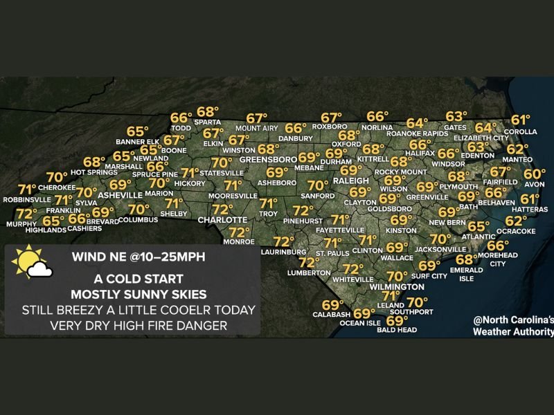
NORTH CAROLINA — After a cold overnight shot of air moved through the state, North Carolina is set to warm up nicely on Tuesday, April 21, 2026, with partly to mostly sunny skies delivering high temperatures in the 60s and low 70s for most of the region. While the warming trend brings welcome relief from the morning chill, forecasters are urging residents to exercise caution as breezy and very dry conditions are keeping fire danger elevated across the state throughout the day.
Northeast winds ranging from 10 to 25 mph are contributing to the dry and breezy feel, and residents are being asked to avoid any outdoor burning until conditions improve significantly.
Western North Carolina Temperature Forecast
Across the western mountains and foothills, temperatures are expected to climb into the upper 60s and low 70s by Tuesday afternoon. Murphy and Franklin are forecast to reach highs near 72 degrees, while Cherokee and Robbinsville are projected at 71 degrees. Asheville and Marion are each expected to hit around 70 degrees, with Hot Springs forecast near 68 degrees.
At higher elevations, temperatures will be somewhat cooler. Banner Elk is projected at 65 degrees, Boone near 65 degrees, and Newland around 65 degrees. Spruce Pine and Marshall are forecast near 66 and 68 degrees respectively, reflecting the typical temperature gradient across the mountain terrain.
Central North Carolina Highs Reaching the Low 70s
Across the central Piedmont region, conditions will be noticeably warmer with several areas touching the low 70s. Charlotte is forecast to reach 72 degrees, with Shelby and Columbus projected near 71 degrees. Statesville is expected to hit 71 degrees, while Mooresville and Hickory are each forecast around 70 to 71 degrees.
Greensboro is projected at 70 degrees, with Winston-Salem near 68 degrees and Asheboro at 71 degrees. Raleigh is forecast to reach 69 degrees, and Sanford is projected near 71 degrees. The Research Triangle corridor, including Durham and Mebane, is expected to see highs around 69 degrees under mostly sunny skies throughout the afternoon.
Eastern North Carolina and Coastal Areas Running Cooler
Temperatures across the eastern portion of the state and along the coast will be somewhat lower, reflecting the influence of northeast winds off the Atlantic. Fayetteville and Laurinburg are forecast near 72 degrees, while Kinston is projected at 69 degrees and New Bern near 69 degrees. Wilmington is expected to reach around 71 degrees, with Surf City and Leland forecast near 70 degrees.
Along the Outer Banks, Hatteras is projected at 61 degrees, with Corolla near 61 degrees and Ocracoke around 62 degrees. Elizabeth City is forecast near 64 degrees and Manteo at approximately 62 degrees, keeping coastal residents in noticeably cooler conditions compared to inland areas.
Elevated Fire Danger Remains a Serious Concern Tuesday
Despite the pleasant warming trend, forecasters are stressing that very dry conditions combined with northeast winds gusting up to 25 mph are maintaining a high fire danger rating across North Carolina on Tuesday. Residents are being strongly urged not to conduct any outdoor burning, and extra caution is advised near wooded or grassy areas that could ignite quickly under current conditions.
The combination of low humidity, dry vegetation, and consistent breezy winds creates conditions where fires can spread rapidly and become difficult to control. Emergency management officials are asking the public to remain vigilant and report any signs of smoke or fire immediately to local authorities.
Are you experiencing the warming temperatures or keeping an eye on fire danger conditions in your part of North Carolina today? Share your observations and stay informed with the latest weather coverage at SaludaStandard-Sentinel.com.