Oklahoma Severe Thunderstorm Warning Issued for Blanchard Noble and Norman With 60 MPH Winds and Quarter-Sized Hail Moving Northeast at 45 MPH
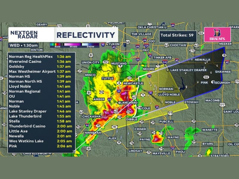
OKLAHOMA — A Severe Thunderstorm Warning was issued at 1:30 AM Wednesday, April 15, 2026, for Blanchard, Noble, and Norman as a fast-moving and dangerous storm system pushed northeast at 45 miles per hour, threatening dozens of communities across central Oklahoma with winds up to 60 mph and quarter-sized hail. The warning was issued by KWTV News 9 in coordination with the National Weather Service, with radar showing 59 total lightning strikes already recorded from the storm.
The storm’s rapid northeastern track placed a wide corridor of central Oklahoma communities on a tight timeline, with arrival times for the most intense activity projected within minutes for several heavily populated areas including Norman, Moore, Newcastle, and surrounding suburbs.
Communities in the Direct Path of the Storm
Radar tracking data outlined a detailed list of communities and landmarks directly in the storm’s projected path, along with estimated arrival times for the most severe conditions. Norman Regional HealthPlex, Riverwind Casino, and Goldsby were among the first in line, with impacts expected as early as 1:36 to 1:37 AM. Norman High School, Norman North High School, Lloyd Noble arena, and the University of Oklahoma campus were all projected to experience storm impacts by 1:39 to 1:41 AM.
Further along the storm’s track, Noble was expected to be impacted by 1:45 AM, followed by Lake Stanley Draper at 1:46 AM, Lake Thunderbird at 1:55 AM, and communities including Stella, Thunderbird Casino, Little Axe, Newalla, Wes Watkins Lake, and Pink facing impacts between 1:58 AM and 2:06 AM.
What the Warning Means for Residents
A Severe Thunderstorm Warning is a serious alert indicating that severe weather is either already occurring or imminent in the warned area. With winds capable of reaching 60 mph, significant structural damage to trees, power lines, and buildings is possible. Quarter-sized hail measuring approximately one inch in diameter can cause damage to vehicles, rooftops, and windows, and poses a direct physical danger to anyone caught outdoors.
Residents across the warned counties should immediately move indoors and away from windows. Those in mobile homes or temporary structures should seek sturdier shelter immediately, as high winds pose a significant collapse risk to these types of dwellings.
Staying Safe During a Fast-Moving Severe Thunderstorm
With the storm tracking northeast at 45 mph, residents in its path had very limited time to react and seek shelter. Anyone in the Norman, Blanchard, or Noble areas who had not yet taken shelter needed to do so immediately upon receiving the warning, as the window for safe preparation was extremely narrow given the storm’s speed of movement.
Residents should stay away from windows, avoid using electrical appliances, and remain in an interior room on the lowest floor of a sturdy building until the storm passes. Do not venture outside to assess damage until authorities confirm the severe weather threat has completely cleared the area.
Were you in the path of Wednesday morning’s severe thunderstorm across central Oklahoma? Share your experience and stay updated with the latest severe weather coverage at SaludaStandard-Sentinel.com.