Michigan Severe Storm Line Targets Southeast Corner With Flash Flooding Concerns Spreading Across Lower Michigan Early Wednesday Morning
LOWER MICHIGAN — A dangerous line of severe storms is pushing toward the far southeast corner of Michigan in the early morning hours of Wednesday, April 15, 2026, while flash flooding concerns are simultaneously spreading across much of lower Michigan as relentless overnight rainfall continues to saturate the region. Forecasters were live monitoring the situation as of 1:22 AM Eastern Time, urging residents in the storm’s path to remain alert.
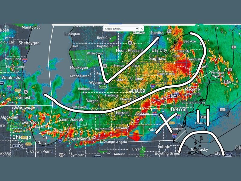
Radar imagery showed an intense line of storms stretching across a broad swath of the state, with the heaviest activity concentrated in the central and eastern portions of lower Michigan, including areas around Saginaw, Bay City, Lansing, and communities east toward Macomb Township and the Detroit metro region.
Southeast Michigan Residents Urged to Stay Alert
While residents behind the storm line were given the all-clear to rest for the night, those living in the far southeast corner of Michigan face a different situation entirely. A significant line of severe storms was approaching this zone as of the early morning hours, prompting forecasters to urge residents in communities including Monroe, Detroit, St. Clair Shores, and surrounding areas to remain tuned in to live weather coverage rather than going to sleep.
The storm line visible on radar showed extremely intense reflectivity values pushing eastward, indicating the potential for damaging winds, heavy rain, and lightning as the system moves through the southeastern corner of the state in the hours ahead.
Flash Flooding a Widespread Concern Across Lower Michigan
Beyond the immediate severe storm threat, flash flooding concerns have emerged as a significant secondary danger affecting much of lower Michigan. The prolonged period of heavy rainfall associated with this storm system has already saturated soils across the region, meaning additional rainfall has nowhere to go and runoff into roadways, low-lying areas, and waterways is occurring rapidly.
Communities across lower Michigan, including areas around Lansing, Jackson, Saginaw, Bay City, and points throughout the central part of the state, are all facing elevated flash flood risk. Residents should avoid driving through flooded roadways under any circumstances, as even shallow moving water can sweep vehicles off roads with little warning.
What Residents Behind the Storm Line Should Know
For the majority of Michigan residents who are already behind the main storm line, the immediate severe weather threat has passed for the overnight hours. However, the flash flooding risk does not end simply because the storm line has moved through — saturated ground and elevated river levels mean that flooding can continue or even worsen in the hours following heavy rainfall.
Residents across lower Michigan should monitor any nearby streams, rivers, or low-lying areas near their homes and be prepared to move to higher ground quickly if water levels begin rising unexpectedly. Local emergency management agencies should be contacted immediately if flooding threatens life or property.
Are you tracking the overnight storm system across Michigan or dealing with flooding in your area? Share your updates and stay connected with the latest weather coverage at SaludaStandard-Sentinel.com.