Illinois Severe Weather Threat Clears for Most Regions as Storms Continue Targeting Rockford and Chicago Area
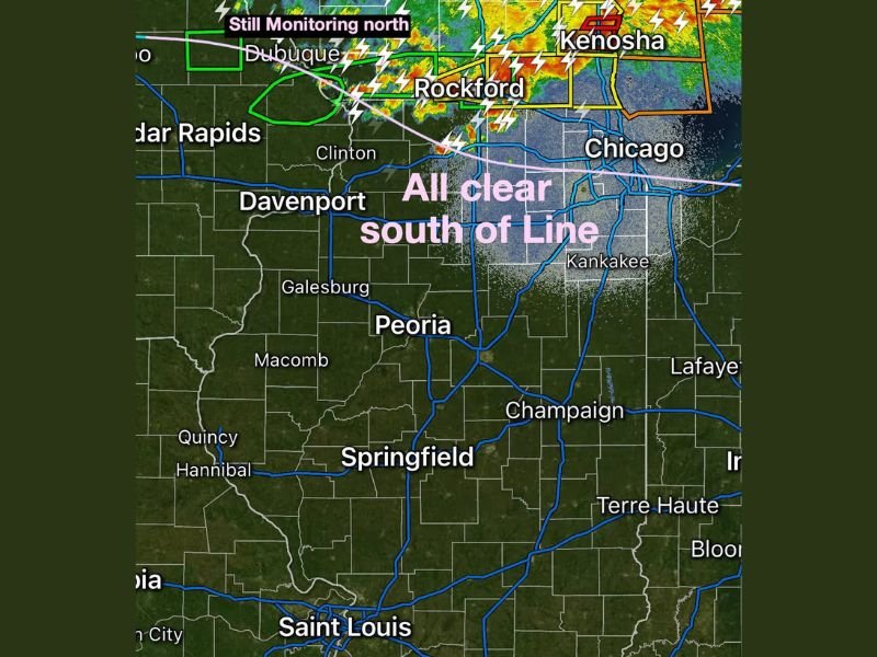
ILLINOIS — Most of the state has received an all-clear from severe weather threats Tuesday night, with forecasters confirming that Central, Southern, and Northwestern Illinois are no longer at risk as storm activity has pushed northward. However, residents in the northeastern corner of the state from Rockford to Chicago and points further north are urged to continue monitoring conditions closely.
Meteorologists confirmed that the atmospheric cap held across the majority of Illinois throughout the day, preventing widespread storm development and allowing millions of residents to end their severe weather vigilance for the evening.
Where Illinois Stands Clear Tonight
Forecasters issued all-clear status for four major regions of the state — Central Illinois, Southern Illinois, Northwestern Illinois, and most of Northeastern Illinois south of the Rockford-to-Chicago line. Residents in Peoria, Springfield, Champaign, Quincy, Macomb, Galesburg, Davenport, and Kankakee can rest easy as the severe weather window has closed for their areas.
The cap holding across these regions proved to be a significant factor in limiting storm development, which forecasters described as a welcome outcome for the vast majority of the state’s population.
Northeastern Illinois Still Under Watch
The one area that remains a concern is the corridor stretching from Rockford northeast toward Kenosha and the greater Chicago area. Radar imagery showed active storm cells with lightning and intense reflectivity in this zone, prompting forecasters to maintain active monitoring for communities north of the dividing line.
Residents in Rockford, the Chicago metro, and communities near the Illinois-Wisconsin border should remain weather-aware and keep emergency alerts active until the storm system fully clears the region.
What the Cap Holding Means for Residents
The atmospheric cap effectively acted as a lid on storm development across most of Illinois Tuesday, preventing the kind of widespread severe weather that had been a concern earlier in the day. When the cap holds, it suppresses rising air needed to fuel thunderstorm development, resulting in significantly reduced storm activity across the affected region.
While this was good news for most of the state, the northern corridor where the cap broke allowed storms to fire and intensify, which is why the Rockford-to-Chicago zone continues to see active storm activity while the rest of Illinois remains quiet.
Were you tracking tonight’s severe weather threat across Illinois? Share your experience and stay updated with the latest coverage at SaludaStandard-Sentinel.com.