Chicago and Chicagoland Face Early Morning Storms Between 4 and 7 AM Tuesday Before Dangerous Afternoon Event Threatens Extremely Large Hail and Tornadoes
ILLINOIS — A 9:30 PM Monday update is painting a two-stage and potentially dangerous weather picture for Chicagoland heading into Tuesday. New data shows thunderstorms dropping south into the Chicago area between 4 and 7 AM, bringing gusty winds and heavy rain before clearing. Then Tuesday afternoon brings a second and far more dangerous event where all hazards including extremely large hail and tornadoes will be at play if storms manage to fire across the region.
Early Morning Storms Dropping Into Chicagoland Between 4 and 7 AM
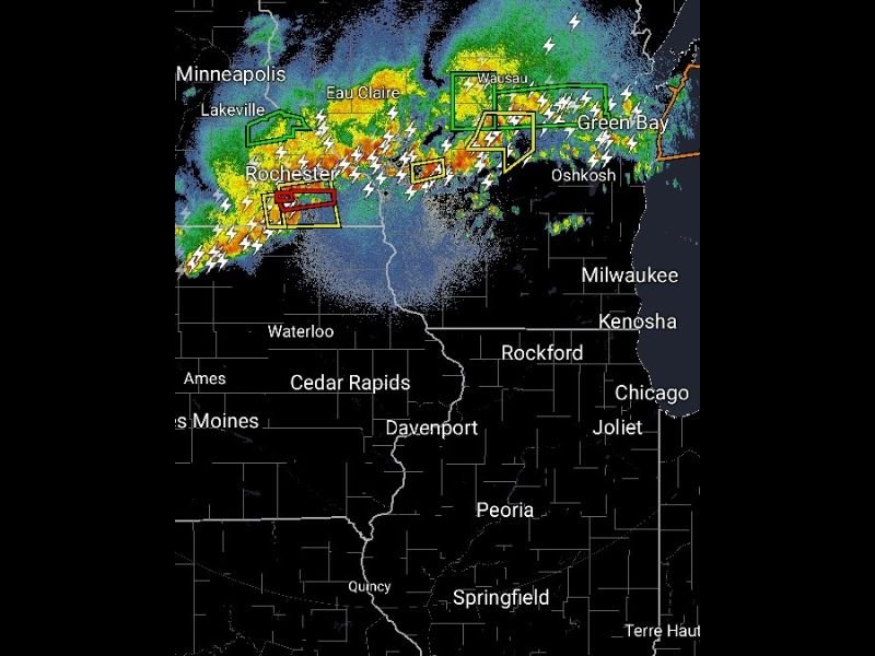
The first stage of Tuesday’s weather story is an overnight and early morning storm complex currently firing across Minnesota and Wisconsin. Radar at 9:30 PM Monday shows intense activity with tornado warnings and severe thunderstorm warnings active across Rochester, Eau Claire, Wausau, Green Bay, and Oshkosh.
This complex is expected to drop south into Chicagoland between 4 and 7 AM Tuesday morning. Gusty winds and heavy rainfall are the primary concerns with this early round. Residents should be aware that overnight storm activity may disrupt sleep and cause localized power outages across the northern Chicago suburbs during the pre-dawn hours.
Cap Questions Remain for Tuesday Afternoon Event
The bigger concern for Tuesday is the afternoon and evening severe weather potential across Chicagoland. Forecasters describe the atmosphere as genuinely dangerous, with data supporting an extremely volatile environment capable of producing violent storms if the atmospheric cap breaks sufficiently.
However significant uncertainty remains around cap strength across the Chicago area. There is a real possibility that storms may fire to the north and largely miss Chicagoland during Tuesday evening. Storm coverage remains uncertain, making this a difficult forecast to pin down with high confidence heading into Tuesday morning.
All Hazards Including Giant Hail and Tornadoes Possible If Storms Fire
If storms do manage to push into the Chicagoland area Tuesday afternoon and evening, forecasters are warning that all hazards will be at play without exception. Extremely large hail and tornadoes are both on the table within any supercell that develops and reaches the Chicago metro area during the peak severe weather window.
This is not a situation where residents should assume the uncertainty means they are safe. The cap breaking even partially could unleash violent and dangerous storms with very little warning time across a densely populated area.
Residents across Chicago, Rockford, Joliet, Kenosha, and surrounding communities must have weather alerts fully active on Tuesday and know exactly where to shelter if warnings are issued.
Check back for morning updates as the forecast becomes clearer. Stay weather aware at SaludaStandard-Sentinel.com.