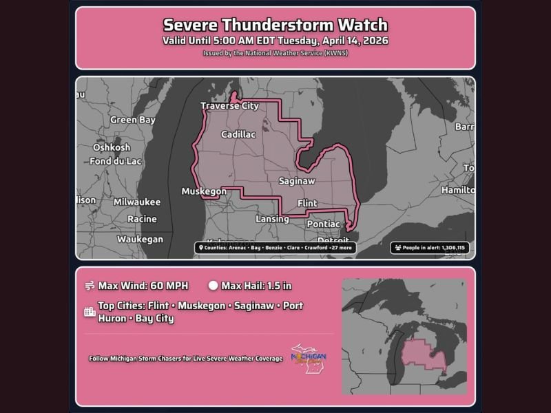
Michigan Severe Thunderstorm Watch Issued for Flint, Muskegon, Saginaw and 27 Counties Until 5 AM Tuesday With 60 MPH Winds and 1.5 Inch Hail Threatening 1.3 Million People
MICHIGAN — The National Weather Service has issued a Severe Thunderstorm Watch for a massive swath of Michigan covering more than 27 counties and placing over 1.3 million people under alert until 5:00 AM EDT Tuesday, April 14, 2026. The watch covers a broad corridor stretching from Traverse City and Cadillac in the north through Muskegon, Saginaw, Flint, Pontiac, and toward the Detroit metro area, with maximum wind gusts of 60 MPH and hail up to 1.5 inches possible within the strongest storm cells overnight.
Over 1.3 Million Michigan Residents Under Severe Thunderstorm Watch
The scale of this Severe Thunderstorm Watch is significant. With 1,306,115 people currently under alert across Michigan, this is a widespread and serious overnight severe weather threat that demands attention from residents across the entire watch zone. The watch is valid until 5:00 AM EDT Tuesday, meaning dangerous storm conditions could persist through the overnight hours and into the pre-dawn period Tuesday morning.
Top cities directly under this watch include Flint, Muskegon, Saginaw, Port Huron, and Bay City. Residents in all of these communities and across all 27 listed counties should remain weather aware and keep alerts active on their devices throughout the night.
60 MPH Wind Gusts and 1.5 Inch Hail Are the Primary Threats
The two primary hazards driving this Severe Thunderstorm Watch across Michigan are damaging wind gusts reaching up to 60 MPH and hail up to 1.5 inches in diameter. Wind gusts at 60 MPH are strong enough to snap tree branches, down power lines, and cause significant structural damage to poorly constructed or older buildings across the region.
Hail at 1.5 inches in diameter is approaching golf ball size and is capable of shattering vehicle windshields, damaging roofs, and injuring anyone caught outdoors during the heaviest storm activity. Residents should move vehicles into garages or covered areas if possible before storms arrive.
Full List of Counties Under the Watch
The Severe Thunderstorm Watch covers Arenac, Bay, Benzie, Clare, Crawford, Genesee, Gladwin, Grand Traverse, Gratiot, Huron, Isabella, Kalkaska, Lake, Lapeer, Manistee, Mason, Mecosta, Midland, Missaukee, Montcalm, Muskegon, Newaygo, Oceana, Ogemaw, Osceola, Roscommon, Saginaw, St. Clair, Sanilac, Shiawassee, Tuscola, and Wexford County.
Every resident across these counties must treat tonight as an active severe weather night. Do not ignore this watch simply because it is overnight. Severe thunderstorms after dark are among the most dangerous because many residents are asleep when warnings are issued.
Keep weather alerts active on your phone tonight. Stay informed at SaludaStandard-Sentinel.com.