Large Tornado Confirmed South of Kansas City Near Ottawa and Wellsville as Oklahoma Reloads for Higher Severe Storm Risk Across a Larger Area Monday
KANSAS AND OKLAHOMA — A large tornado is on the ground south of Kansas City right now, tracking through an area that sits ironically outside the greater risk zone that forecasters had outlined earlier in the day. Meanwhile Oklahoma, which saw its expected storm activity fail to materialize Sunday, is reloading for a significantly higher severe storm risk tomorrow that will threaten a larger portion of the state. Monday is shaping up to be a dangerous day across the region and residents need to be prepared well before storms fire.
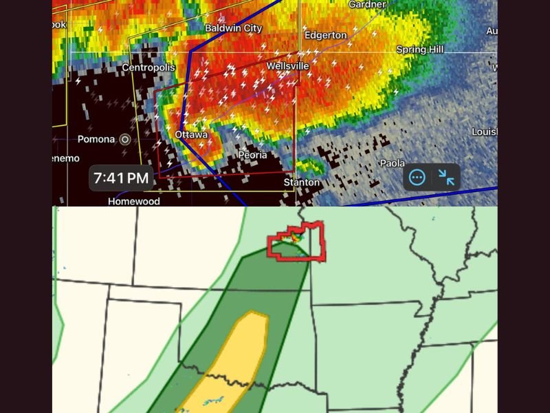
Large Tornado Confirmed South of Kansas City at 7:41 PM
Radar at 7:41 PM is showing a dangerous and clearly defined tornadic storm south of Kansas City, with the most intense rotation and precipitation cores concentrated over Ottawa, Wellsville, Peoria, and Stanton. The warning polygon is active and clearly outlined on radar, with extremely intense red and orange returns surrounding a tight rotation signature that confirms an ongoing tornado threat for communities in this immediate area.
Surrounding communities including Baldwin City, Centropolis, Edgerton, Spring Hill, Gardner, and Paola are all in close proximity to this storm’s path and must remain on high alert. Anyone in or near Ottawa and Wellsville who has not yet taken shelter must do so immediately without any delay.
Storm Outside the Greater Risk Area Highlights Unpredictability
One of the most alarming aspects of tonight’s Kansas tornado event is that it is occurring outside the area that forecasters had identified as carrying the greatest risk for tornado development. This serves as a critical reminder that tornadoes do not respect risk zone boundaries on a map.
Any active severe weather day carries the potential for dangerous storms to develop in areas where the overall threat level appears lower. Staying weather aware across the entire region during any active period is absolutely essential regardless of what risk category your county falls under on the official outlook.
Oklahoma Reloads With Higher Risk Monday for Larger Area
While Sunday’s severe weather in Oklahoma failed to materialize as expected, forecasters are warning that Monday brings a reset with a higher severe storm risk threatening a larger portion of the state. The setup for Monday is expected to be more favorable for widespread severe weather development across Oklahoma compared to what was in place Sunday.
Residents across Oklahoma must not let Sunday’s quiet lull them into complacency heading into Monday. Storm crews will be back out in force and every resident should have weather alerts active, shelter plans finalized, and full awareness of Monday’s developing threat before storms fire. Stay weather aware at SaludaStandard-Sentinel.com.