Pennsylvania Watching for Storm Clusters Tuesday Afternoon as Heat, Humidity and Wind Shear Could Trigger Strong Storms From Pittsburgh to Philadelphia and Scranton
PENNSYLVANIA — Storm clusters are being closely watched across Pennsylvania for Tuesday afternoon as a combination of heat, humidity, and wind shear creates the potential for stronger than normal storm activity across much of the state. While Tuesday is not expected to be an extreme severe weather day, pockets of gusty winds and lightning cannot be ruled out, and anyone with outdoor plans for Tuesday afternoon should keep an umbrella and raincoat within reach throughout the day.
Storm Clusters Possible Across Pennsylvania Tuesday Afternoon
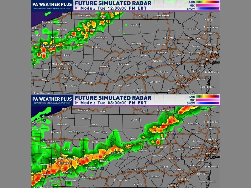
Model guidance is showing the potential for a few clusters of storms to develop across Pennsylvania during Tuesday afternoon hours. The future simulated radar from PA Weather Plus shows storm activity beginning to fire across western Pennsylvania near Pittsburgh, Youngstown, Oil City, and Warren around noon, with additional clusters developing and expanding eastward toward Scranton, Allentown, and Philadelphia by 3 PM.
The storms developing Tuesday will be heavily dependent on what happens with the current severe weather outbreak across the Midwest. As those storms move eastward and fizzle out overnight, they will leave behind remnant outflow boundaries that could serve as the primary trigger points for Tuesday afternoon storm development across Pennsylvania.
Heat, Humidity and Wind Shear Fueling Storm Potential
The atmospheric ingredients coming together for Tuesday are worth monitoring closely across Pennsylvania. Above normal heat combined with elevated humidity levels will build instability throughout the morning hours, and wind shear present across the region means any storms that do develop could organize quickly and reach the stronger end of the non-severe spectrum.
While the overall severe weather threat for Pennsylvania on Tuesday appears relatively low, forecasters are not dismissing the possibility of isolated gusty winds and frequent lightning within the strongest storm clusters, particularly across western and central Pennsylvania where the outflow boundary influence may be most pronounced during the early afternoon hours.
What Pennsylvanians Should Do Before Tuesday Afternoon
Given the current level of uncertainty surrounding Tuesday’s storm potential, residents across Pennsylvania are advised to stay flexible with any outdoor plans scheduled for the afternoon hours. The storm picture will become clearer by Tuesday morning as outflow boundary positions become better defined and model guidance firms up.
Communities across the western part of the state including Pittsburgh, Greenville, Butler, Johnstown, and Indiana should be among the first areas to see storm development around noon. Eastern communities including Harrisburg, Reading, Lancaster, Philadelphia, and Scranton could see storm clusters arriving during the mid to late afternoon hours.
Keep weather alerts active on your phone throughout Tuesday afternoon and be prepared to move indoors quickly if storms develop near your location. Stay weather aware at SaludaStandard-Sentinel.com.