Florida and Southern States Could See Quiet Hurricane Season but Active Fall Storms as Record-Strength El Niño Signals 2 to 3°C Pacific Warming
UNITED STATES — A potentially record-breaking El Niño is developing in the Pacific Ocean, and new forecast data suggests it could significantly reshape weather patterns across Florida and the southern United States through the rest of 2026.
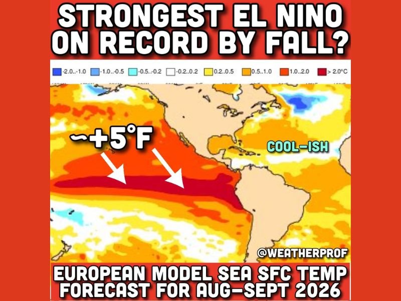
The latest seasonal outlook shows sea surface temperatures in the central and eastern Pacific running 2 to 3°C above normal, levels that could surpass previous records and place this event among the strongest El Niño episodes ever observed.
Record Pacific Warming Signals a Historic El Niño Event
Forecast models indicate ocean temperatures could exceed previous benchmarks set during major El Niño years, including 2015.
This level of warming, equivalent to roughly 5°F above normal in key regions of the Pacific, plays a critical role in shifting global weather patterns. Such a strong signal increases the likelihood of widespread atmospheric changes that extend far beyond the Pacific basin and into North America.
Atlantic Hurricane Season Could Be Noticeably Quieter
One of the most immediate impacts of a strong El Niño is its influence on the Atlantic hurricane season. Warmer Pacific waters typically lead to increased wind shear over the Atlantic, which disrupts the formation and strengthening of tropical systems.
As a result, forecasts suggest the upcoming hurricane season could be relatively quiet overall, with a lower chance of storms making landfall in the United States.
Florida and the South May See Active Fall and Winter Storm Patterns
While a quieter hurricane season may sound like good news, El Niño often brings a different kind of risk later in the year.
An energized subtropical jet stream can lead to multiple rounds of severe weather, including thunderstorms, tornadoes, and heavy rainfall across Florida and the southern states.
This pattern tends to become more noticeable during fall and winter, when storm systems become more frequent and organized.
Past El Niño Events Show Increased Tornado and Rain Risk
Historical examples show that strong El Niño years have been linked to increased severe weather activity in parts of the southern United States.
Central Florida, in particular, has experienced some of its most notable tornado events during past El Niño periods, highlighting the potential for impactful weather beyond hurricane season. In addition, repeated storm systems can increase the risk of flooding, especially in areas prone to heavy rainfall.
Global Temperatures Could Surge Alongside El Niño
Another major effect of a strong El Niño is its contribution to rising global temperatures. These events release stored ocean heat into the atmosphere, amplifying global warming trends and increasing the likelihood of record-breaking heat worldwide.
Early projections suggest that upcoming years could rank among the warmest ever recorded, driven in part by this developing pattern.
What This Means for the Months Ahead
As this powerful El Niño continues to develop, its influence will likely be felt across multiple seasons, from summer through winter. Residents in Florida and across the southern United States should prepare not just for a potentially quieter hurricane season, but also for an active stretch of storms later in the year.
Staying informed and prepared will be key as this evolving climate pattern continues to shape weather conditions. As this historic El Niño develops, how do you think it will impact your area? Share your thoughts with us at SaludaStandard-Sentinel.com.