Midwest and Great Lakes States Face Post Easter Cold Blast With Temperatures Dropping 10 to 20 Degrees Below Normal and Frost Risk Expanding South
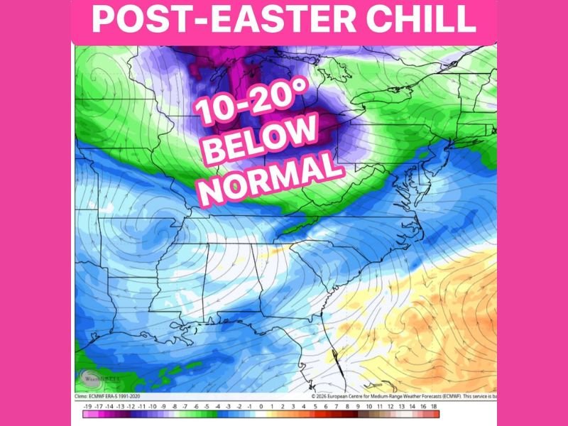
UNITED STATES — A sharp shift in weather is expected after Easter as a widespread cold air mass moves into the Midwest and Great Lakes, bringing temperatures 10 to 20 degrees below normal and increasing the risk of frost and freezing conditions by midweek.
The cold surge is forecast to expand southward from the Upper Midwest into parts of the Ohio Valley and interior Southeast, marking a noticeable return to winter-like conditions after recent mild weather.
Cold Air Mass Pushes Across Midwest and Great Lakes
Forecast models indicate the core of the coldest air settling across states including Minnesota, Wisconsin, Michigan, Illinois, Indiana, and Ohio. These areas are expected to experience the most significant temperature drops, with daytime highs running well below seasonal averages.
The cold air will gradually spread southeastward, reaching parts of Kentucky, Tennessee, and the Carolinas, where cooler-than-normal conditions are also expected.
Temperatures Falling Well Below Seasonal Norms
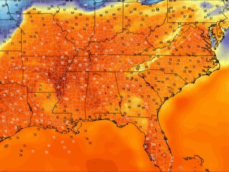
The projected temperature anomalies show widespread departures of 10 to 20 degrees below normal across a large portion of the central and eastern United States. This means areas that would typically see mild spring temperatures could instead experience conditions more typical of late winter.
Nighttime temperatures are expected to drop sharply, increasing the potential for frost formation, especially in rural and low-lying areas.
Frost and Freeze Risk Increasing by Midweek
As the cold air settles in, frost and freeze conditions could develop across parts of the Midwest and extend into mountainous regions of the Appalachians. Sensitive vegetation and early spring growth may be at risk if temperatures dip low enough overnight.
Higher elevations are particularly vulnerable, where colder air tends to settle and persist longer during overnight hours.
Cooler Pattern Signals Brief Return to Winter-Like Conditions
This post-Easter cooldown represents a temporary but notable pattern shift, driven by a large-scale trough bringing colder air southward. While not unusual for early April, the magnitude of the temperature drop could catch many off guard.
Residents are advised to prepare for colder mornings and potential impacts to outdoor plans, especially during the middle of the week when temperatures are expected to be at their lowest.
Gradual Moderation Expected After Midweek
While the cold snap will be significant, it is not expected to last long-term. Temperatures should gradually begin to moderate later in the week as the cold air mass moves out and more typical spring conditions return.
Until then, residents across the affected regions should plan for colder-than-normal conditions and take precautions to protect plants and sensitive outdoor items.
If you’re experiencing the sudden temperature drop in your area, share your conditions with us at SaludaStandard-Sentinel.com and help others prepare for the changing weather.