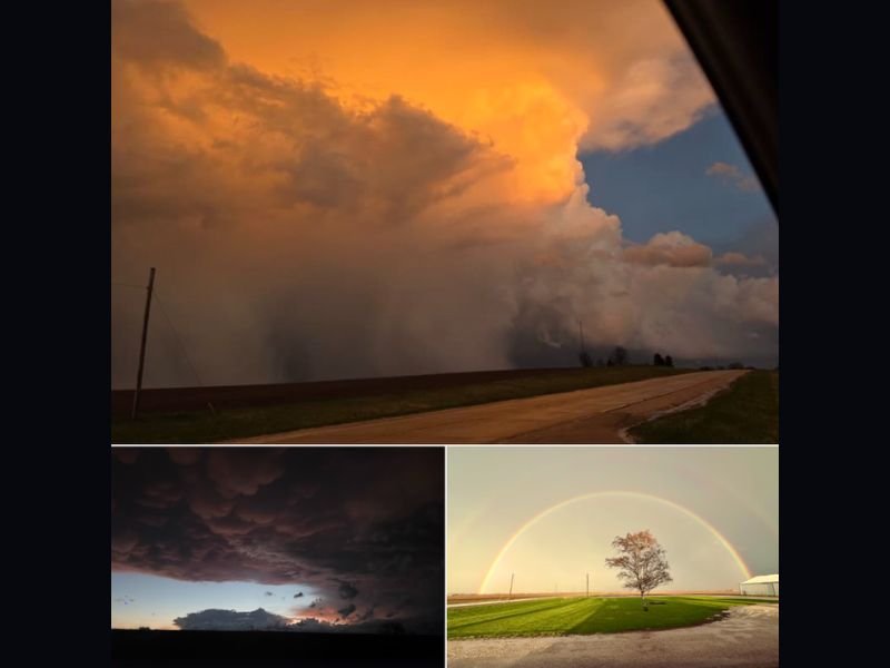
Stunning Storm Photos Across Central Illinois Capture Towering Thunderstorms Mammatus Clouds and Brilliant Rainbow After Evening System
CENTRAL ILLINOIS — A series of powerful evening thunderstorms left behind not only rain and lightning but also breathtaking skies across Central Illinois, as residents captured dramatic cloud formations and a vivid rainbow following the storms.
From towering thunderstorm structures near Speer to rare mammatus clouds and a colorful rainbow over Wyoming, Illinois, the visuals highlight the intensity and beauty of the system that moved through the region.
Towering Thunderstorm Near Speer Dominates the Sky
One of the most striking images shows a massive thunderstorm structure passing south of Speer, Illinois. The towering cloud formation, illuminated by the setting sun, reveals the depth and strength of the storm as heavy rain curtains fall beneath it.
These types of storm structures often indicate strong updrafts and active precipitation cores, which were present as the system moved across the area.
Mammatus Clouds Form After Storm Near Major Interstate Corridor
Another image captured near the I-39 and I-80 interchange shows a field of mammatus clouds hanging beneath the storm’s anvil.
Mammatus clouds, which appear as rounded, pouch-like formations, typically develop after strong thunderstorms and are often associated with turbulent air within the storm system. Their presence suggests that the storms earlier in the evening had significant vertical development and energy.
Rainbow Emerges Over Wyoming Illinois After Storm Passes
As skies began to clear, a bright rainbow appeared over Wyoming, Illinois, offering a calm and colorful contrast to the earlier severe weather.
Rainbows form when sunlight breaks through moisture in the atmosphere, signaling that the storm is beginning to move out of the area. This transition from intense storms to clearer skies was evident across much of Central Illinois.
Storm System Delivered Both Impact and Visual Drama
The combination of heavy rain, lightning, and strong storm structures created both hazardous conditions and remarkable visuals.
While some areas experienced brief downpours and lightning, the post-storm atmosphere produced some of the most visually stunning scenes of the evening.
These moments often follow active spring weather patterns, where rapidly changing conditions can produce both severe impacts and striking cloud formations.
Central Illinois Residents Capture the Moment
The images, taken by viewers across the region, highlight how widespread the storm system was and how quickly conditions evolved. From active storm cores to calm skies and rainbows, the sequence of events unfolded within just a few hours. Such rapid transitions are common during spring storm systems in the Midwest.
If you captured storm photos in Central Illinois or witnessed these dramatic skies, share your experience and stay connected with more local weather coverage on SaludaStandard-Sentinel.com.