Fast Moving Tornadic Storm Sweeps From Riverside Iowa to Davenport and Atkinson Illinois With Brief Funnel and Dramatic Shelf Clouds Ending High Speed Chase
IOWA — A rapidly moving storm system tracked from Riverside through eastern Iowa and into western Illinois, producing a brief tornado attempt, intense storm structure, and dangerous chasing conditions before ultimately weakening.
Storm chasers reported extreme difficulty keeping up with the system as storm speeds exceeded 60 mph, making interception nearly impossible after initial development.
Brief Tornado Attempt Near Riverside Before Rapid Dissipation
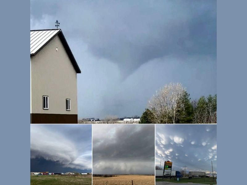
The storm initially showed strong potential near Riverside, Iowa, where a funnel appeared to be forming and briefly organizing. Observers believed the system was on the verge of producing a stronger tornado.
However, the rotation quickly weakened and the funnel dissipated shortly after passing overhead, cutting short what could have been a more significant tornado event.
Storm Speed Made Tracking Extremely Difficult
One of the most notable aspects of this system was its speed. Moving at over 60 mph, the storm outran most attempts to track it closely, even for experienced storm chasers.
Heavy traffic and the number of chasers following the same storm further complicated movement, limiting opportunities for safe positioning and observation.
Powerful Shelf Cloud Rolls Into Davenport Area
As the storm continued east, it transitioned into a more linear structure, producing a dramatic shelf cloud as it approached the Davenport area.
This feature marked a shift from a tornadic setup to a wind-driven system, with strong outflow winds likely becoming the primary hazard. The shelf cloud presented an imposing visual, stretching across the horizon and signaling the arrival of intense winds and heavy rain.
Chase Ends in Atkinson Illinois With Mammatus Clouds
The storm chase concluded in Atkinson, Illinois, where observers noted striking mammatus cloud formations following the storm’s passage.
These pouch-like cloud features often appear after strong storms and indicate turbulent conditions in the upper atmosphere. While visually impressive, they also highlighted the storm’s transition away from severe tornadic potential.
Storm Evolution Highlights Rapidly Changing Conditions
This event showcased how quickly severe weather can evolve — from a potential tornado-producing storm in Iowa to a fast-moving wind-driven system in Illinois within a short time frame.
It also emphasized the challenges posed by high-speed storm systems, which can limit warning lead times and make real-time tracking more difficult.
Residents Urged to Stay Alert During Fast Moving Storms
Even when tornadoes do not fully develop, storms like this can still produce dangerous conditions, including strong winds, heavy rain, and lightning.
Residents across Iowa and Illinois are reminded to remain weather-aware during fast-moving systems, as conditions can change rapidly with little warning. If you witnessed this storm or experienced its impact in your area, share your story and stay connected with continued coverage on SaludaStandard-Sentinel.com.