Tornado Warning Issued Near Pittsburgh, Pennsylvania as Dangerous Storm Targets McKeesport Area With Urgent Shelter Alert
PITTSBURGH, PENNSYLVANIA — A tornado warning has been issued near Pittsburgh, with the most immediate threat focused on McKeesport and surrounding communities as a dangerous storm moves through the region.
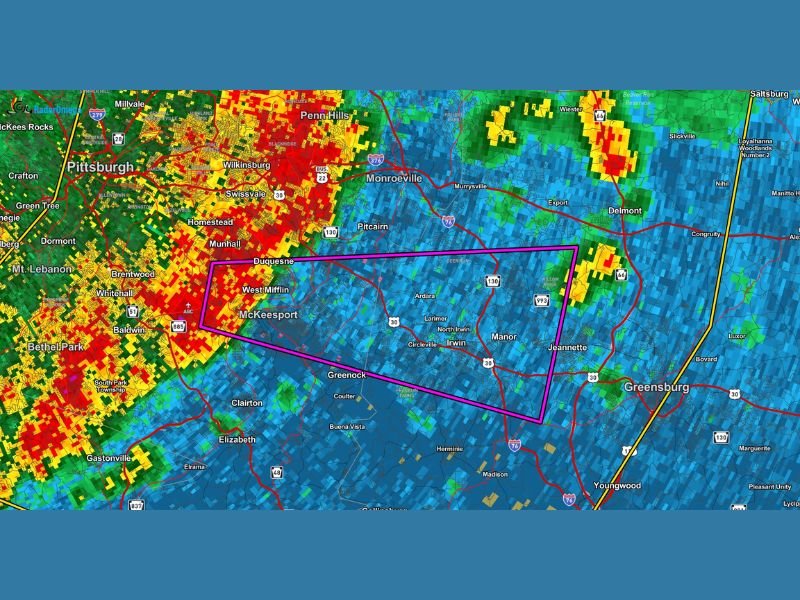
The warning urges residents to seek shelter immediately as radar imagery shows an intense storm cell capable of producing severe weather, including possible tornado activity.
Severe Storm Intensifies Near Pittsburgh Metro Area
Radar data shows a powerful line of storms pushing across the Pittsburgh metro area, with the most dangerous portion highlighted near McKeesport, West Mifflin, and Duquesne. The storm appears highly organized, with strong rotation signals embedded within heavy rainfall.
The western side of the system, particularly closer to Pittsburgh and areas like Baldwin and Bethel Park, is showing extremely intense reflectivity, indicating heavy rain, strong winds, and potential embedded circulation. This is typically where the highest tornado risk can develop during such events. Officials warn that conditions can change rapidly, especially as storms interact with urban terrain and shifting wind patterns.
McKeesport and Nearby Communities in Direct Path
The warning polygon clearly places McKeesport, West Mifflin, Duquesne, and nearby communities directly in the storm’s path. Areas extending toward Monroeville and Greensburg are also being monitored as the system continues moving east.
Residents in these locations should not wait for visual confirmation of a tornado. The storm is already producing conditions favorable for rapid development, including strong wind shear and heavy precipitation.
Emergency management officials emphasize that even if a tornado does not fully form, damaging straight-line winds and sudden bursts of severe weather can still pose a serious threat to life and property.
Primary Threats Include Tornadoes and Damaging Winds
The main hazards with this storm include:
- Possible tornado formation within the warning area
- Damaging wind gusts capable of downing trees and power lines
- Intense rainfall reducing visibility and causing localized flooding
The radar signature suggests that rotation is possible within the storm structure, which is why the tornado warning has been issued instead of a standard severe thunderstorm warning.
Urgent Safety Measures Advised Immediately
Residents in the warned area are strongly advised to:
- Move to a basement or an interior room on the lowest floor
- Stay away from windows and exterior walls
- Avoid traveling unless absolutely necessary
- Monitor local alerts and weather updates continuously
Time is critical during tornado warnings, and delays in taking shelter can significantly increase risk.
Storm Expected to Continue Eastward Overnight
As the storm progresses eastward from Pittsburgh, additional communities could come under threat in the coming hours. The system shows signs of maintaining strength as it tracks toward areas like Greensburg and beyond.
Meteorologists indicate that this is part of a broader severe weather pattern impacting the region tonight, meaning further warnings could be issued as conditions evolve.
Residents should remain alert even after the initial storm passes, as trailing cells or redevelopment can occur. Residents in Pittsburgh, McKeesport, and surrounding Pennsylvania communities are encouraged to share updates and stay connected with ongoing coverage at SaludaStandard-Sentinel.com.