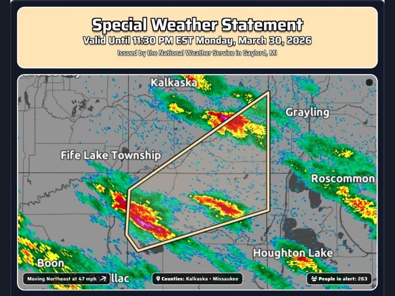
Michigan Kalkaska and Missaukee Counties Under Special Weather Statement With 1/2 Inch Hail and Fast-Moving Storm Until Late Night
MICHIGAN — A Special Weather Statement has been issued for Kalkaska and Missaukee Counties Monday night as a fast-moving storm system pushes through the region with the potential for small hail and gusty conditions. The advisory remains in effect until 11:30 PM EDT, with storms continuing to track northeast across northern Michigan.
Special Weather Statement Highlights Active Storm Threat
The National Weather Service issued the statement as radar indicated a line of stronger storms moving through the area. While not classified as a severe thunderstorm warning, the system is still capable of producing impactful weather in localized areas.
Officials note that conditions can change quickly within these storm bands, especially as they move at a relatively fast pace across the region.
Hail and Fast Storm Movement Main Concerns
The primary hazard associated with this system is hail up to half an inch in diameter, which can briefly intensify within stronger storm cores. While smaller than severe criteria, this hail can still create minor damage and hazardous conditions, particularly for drivers.
In addition, the storms are moving northeast at around 40 mph, meaning affected areas could see rapidly changing weather in a short amount of time.
Storm Line Moving Across Northern Michigan Communities
Radar imagery shows multiple storm cells extending across Kalkaska, Missaukee, and nearby areas, with additional activity stretching toward Grayling and Houghton Lake.
Communities within the highlighted zone may experience brief heavy rain, small hail, and gusty winds as each storm cell passes through.
Short-Duration but Noticeable Impacts Expected
Because of the speed of these storms, impacts in any one location are expected to be relatively brief. However, bursts of heavier precipitation and hail could still reduce visibility and create sudden travel hazards. Drivers and residents are advised to remain alert as conditions may deteriorate quickly even if the storms do not linger long.
Residents Advised to Stay Weather Aware
Officials encourage residents to monitor local weather updates and be prepared for quick changes in conditions through the late evening hours.
Even lower-end storm systems like this can produce isolated impacts, especially when multiple cells pass through in succession. Stay updated and share conditions in your area by visiting SaludaStandard-Sentinel.com.