Michigan, Illinois, Indiana and Ohio Face Level 2 Severe Storm Risk With Damaging Winds, Hail and Possible Tornado Tuesday Afternoon
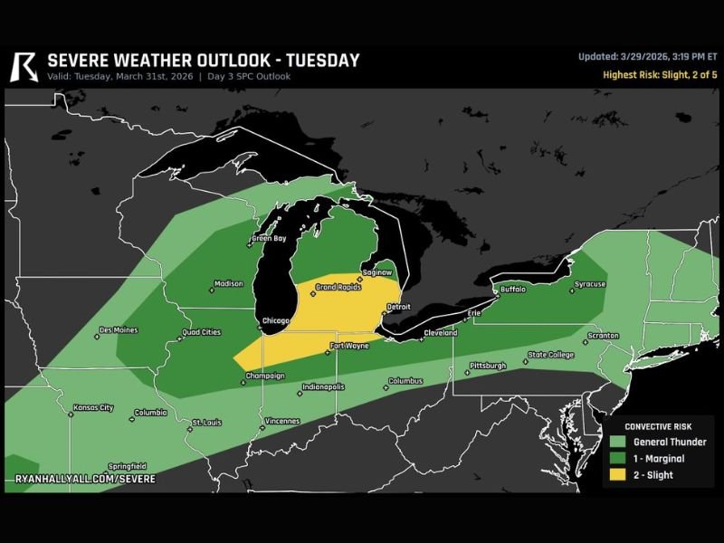
UNITED STATES — A Level 2 severe weather risk is in place for parts of the Great Lakes and Midwest on Tuesday, with storms expected to impact Michigan, Illinois, Indiana, and Ohio through the afternoon and evening hours.
The primary threats include damaging winds and hail, though a conditional tornado risk may develop if storms can strengthen ahead of an approaching front.
Level 2 Risk Zone Centers on Lower Michigan and Surrounding States
The latest outlook highlights Lower Michigan as a focal point for the strongest storm potential, with surrounding areas in eastern Illinois, Indiana, and Ohio also included in the risk zone.
Cities such as Grand Rapids, Detroit, Fort Wayne, and portions of northern Indiana and northwest Ohio fall within the higher-end threat area. This region is expected to see the most organized storm activity during peak hours.
The broader surrounding region, including parts of Wisconsin, western Pennsylvania, and upstate New York, may also experience general thunderstorms, though with lower intensity.
Damaging Winds and Hail Expected as Primary Threats
Fast-moving storms are expected to develop across the region, bringing a heightened risk of damaging straight-line winds. These winds could be strong enough to bring down trees and power lines in localized areas.
Hail is also a concern, particularly in stronger storm cells where updrafts are capable of supporting larger hailstones. Because storms are expected to move quickly, impacts may occur suddenly, giving residents limited time to react once warnings are issued.
Conditional Tornado Risk Depends on Storm Development Ahead of Front
While tornado risk is not the primary concern, it remains possible under the right conditions. If storms are able to form ahead of the advancing cold front and tap into unstable air, isolated tornadoes could develop.
This type of setup is considered “conditional,” meaning not all areas will see tornado activity, but the risk cannot be ruled out in stronger storms. Forecasters will be closely monitoring storm structure and timing to determine whether this threat becomes more significant.
Active Afternoon Into Evening Expected Across the Region
The timing of this event suggests that storm activity will ramp up during the afternoon hours and continue into the evening.
This period typically brings increased instability, which can help storms intensify quickly. Residents should be especially alert during late afternoon and early evening when conditions are most favorable for severe weather. Travel and outdoor plans during this time could be impacted by rapidly changing weather conditions.
Residents Urged to Stay Alert as Conditions Develop
Although not every location will experience severe weather, those within the highlighted risk areas should remain prepared for possible warnings. Monitoring weather alerts and having a plan in place can help reduce risks if severe storms develop quickly.
As conditions evolve throughout the day, updates will refine the exact areas of greatest concern. Stay informed and share your local conditions or concerns by visiting SaludaStandard-Sentinel.com.