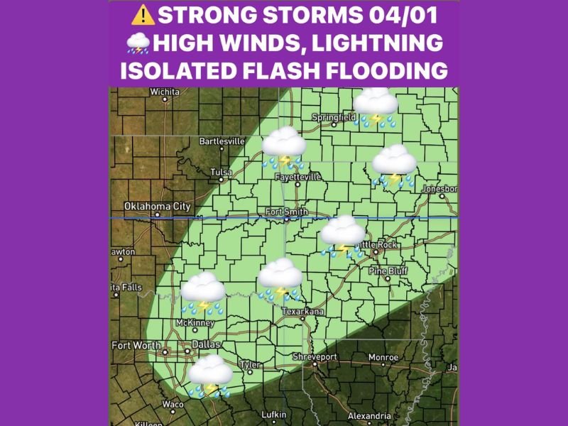
Texas, Oklahoma and Arkansas Face Strong Storm Threat Wednesday With High Winds, Lightning and Isolated Flash Flood Risk
TEXAS, OKLAHOMA, ARKANSAS — A developing storm system is expected to bring a round of strong thunderstorms across parts of the Southern Plains and Lower Mississippi Valley late Tuesday night into Wednesday, with the potential for gusty winds, lightning, and localized flooding.
Meteorologists say the setup includes a surge of Gulf moisture, an active dryline, and an approaching cold front—ingredients that could support organized storm development across the region.
Storms Expected to Develop Late Tuesday Night
Forecast data indicates that showers and thunderstorms will begin forming late Tuesday evening, particularly across parts of Oklahoma and northern Texas, before expanding eastward overnight.
By early Wednesday morning, storms are expected to be ongoing across much of Arkansas and surrounding areas. This timing could impact early commuters and overnight travel, especially where heavier rain develops. The overnight nature of the system adds an additional layer of concern, as visibility and awareness are typically reduced.
Key Threats Include Wind, Lightning and Heavy Rain
The primary hazards with this system will be strong wind gusts, frequent lightning, and pockets of heavy rainfall. Wind gusts could become strong enough to cause minor damage, including downed branches and isolated power outages. Lightning will also pose a risk to anyone outdoors during storm activity.
Heavy rain may develop in localized areas, increasing the potential for brief flooding, especially in low-lying or poor drainage locations.
Isolated Severe Weather Risk Cannot Be Ruled Out
While widespread severe weather is not currently expected, forecasters note that a low-end risk for isolated severe storms exists.
This means a few storms could become stronger than others, potentially producing more intense wind gusts or heavier rainfall over short periods.
Residents are encouraged to monitor updates as conditions evolve, as small changes in the atmosphere could influence storm intensity.
Storm System Driven by Classic Spring Setup
The developing pattern is a classic early spring storm setup, where warm, moist air from the Gulf of Mexico interacts with an advancing cold front and dryline.
This interaction creates instability in the atmosphere, allowing thunderstorms to form and strengthen quickly. Such setups are common across Texas, Oklahoma, and Arkansas during this time of year and can produce a wide range of weather impacts.
Conditions Improve After Storms Move Through
As the cold front pushes eastward, conditions are expected to gradually improve later Wednesday, with storms weakening and skies beginning to clear.
However, additional systems may follow as the active spring pattern continues across the region. Residents should remain alert for changing weather conditions, particularly during the overnight and early morning hours.
Have you experienced overnight storms or strong winds in your area recently? Share your experience and stay updated with the latest weather alerts at SaludaStandard-Sentinel.com.