Central Illinois Faces Level 3 Severe Storm Risk With Baseball Size Hail, 75 MPH Winds and Possible Tornadoes Thursday Afternoon Through Night
ILLINOIS — A significant severe weather upgrade has been issued for Thursday, placing central Illinois under a Level 3 risk zone, signaling a higher likelihood of dangerous storms capable of producing large hail, damaging winds, and even a few tornadoes.
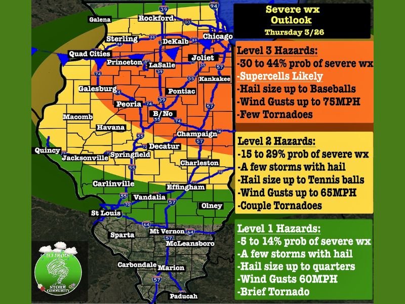
The updated outlook indicates a 30 to 44 percent probability of severe thunderstorms across the region, making this one of the more impactful setups so far this season.
Central Illinois Now in Highest Risk Zone for Severe Storms
The Level 3 risk area stretches across central Illinois, including cities such as Peoria, Bloomington-Normal, Champaign, Decatur, and surrounding communities. This region is expected to see the most intense storm activity as conditions peak later in the day.
Storms developing in this zone will have the highest potential to become supercells, which are capable of producing the most severe weather hazards. Residents in this area should prepare for rapidly changing conditions and stay alert throughout the afternoon and evening hours.
Baseball Size Hail and 75 MPH Winds Highlight Major Threats
One of the primary concerns with Thursday’s storms is the potential for very large hail, with projections indicating hailstones could reach baseball size in the most intense storms.
In addition to hail, wind gusts could reach up to 75 mph, strong enough to cause structural damage, down trees, and lead to widespread power outages. These hazards alone can create dangerous conditions, even without tornado development.
Supercells Could Produce A Few Tornadoes
The storm setup also supports the possibility of a few tornadoes, including the chance that some could be stronger in isolated cases. While not the dominant threat, tornado potential is still present within the Level 3 zone.
Supercells forming ahead of the main line will be the primary concern for any tornado development before storms begin to merge. This adds another layer of risk for areas across central Illinois during peak storm hours.
Storm Timing Expected Between 3 PM and 11 PM
The most active window for severe weather is expected between 3 PM and 11 PM Thursday. During this period, storms are likely to develop, intensify, and move across the region.
Later in the evening, storms may begin to cluster into lines, shifting the primary threat toward damaging winds as they continue eastward. Residents should have multiple ways to receive weather alerts during this timeframe, as conditions could worsen quickly.
Surrounding Areas Face Lower but Still Notable Risk Levels
Areas outside the Level 3 zone, including parts of northern and southern Illinois, remain under lower risk categories. These regions could still see strong storms, but with less intensity compared to central areas.
Level 2 zones carry a 15 to 29 percent chance of severe storms, with hail up to golf ball size and wind gusts near 65 mph possible. Level 1 areas face a lower threat but could still experience isolated storms with smaller hail and gusty winds.
Residents Urged to Prepare Ahead of Severe Weather Threat
With a wide range of severe weather hazards possible, residents across Illinois are encouraged to stay weather-aware and be ready to take action if warnings are issued.
Having a safety plan in place and knowing where to seek shelter could make a critical difference if storms intensify quickly. If you’re in Illinois and preparing for these storms, share what conditions are like in your area by visiting SaludaStandard-Sentinel.com.