Illinois, Indiana and Wisconsin Face Increased Severe Storm Risk With 30 Percent Zone South of I-88 and 2 PM to 8 PM Peak Timing Thursday
ILLINOIS — Confidence is increasing in a more widespread severe weather setup Thursday, with parts of Illinois, Indiana, and southern Wisconsin now facing a heightened risk for strong storms during the afternoon and evening hours.
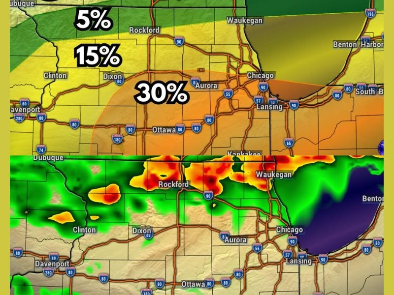
The latest forecast trends show nearly the entire region under some level of severe threat, with the most concerning conditions focused south of the I-88 corridor.
Enhanced Risk Expands Across Illinois and Indiana
The severe weather outlook now includes a Level 3 risk across portions of Illinois and Indiana, particularly in areas south of I-88. This corresponds to roughly a 30 percent chance of storms reaching severe levels in those locations.
Areas farther north, including parts of Wisconsin, remain under lower risk levels, but still have the potential to see strong storms develop. This expanded risk zone indicates that more communities could be impacted compared to earlier forecasts.
Large Hail and Damaging Winds Are Primary Concerns
The main hazards with Thursday’s storms are expected to be large hail and strong wind gusts. Storms reaching severe criteria could produce wind speeds of 58 mph or higher, along with hail exceeding one inch in diameter.
While tornadoes cannot be completely ruled out, the overall tornado threat is considered low and mainly limited to areas south of I-88. Forecasters emphasize that even without tornadoes, these storms can still cause significant localized damage.
Storm Timing Focused Between 2 PM and 8 PM
The most likely window for storm development is currently set between 2 PM and 8 PM Thursday. During this time, conditions will be most favorable for storms to intensify and reach severe levels.
If storms develop earlier in the day, the overall threat may be somewhat reduced. However, if development holds off until later in the afternoon, the risk could increase further. This timing uncertainty means residents should remain alert throughout the afternoon and evening.
Storms Expected to Evolve Into Organized Clusters
Forecast models suggest storms may initially develop as isolated cells before organizing into clusters or short lines as the evening progresses.
This evolution can increase the coverage of impacts, particularly as storms merge and produce stronger wind fields. Communities across the region could see rapidly changing conditions, with storms intensifying quickly once they form.
Residents Urged to Monitor Updates as Situation Evolves
Although confidence in the overall pattern is increasing, there is still some uncertainty regarding the exact timing and placement of the strongest storms.
Additional forecast updates are expected as new data becomes available, and residents are encouraged to stay informed throughout the day. Preparedness will be key, especially for those in the higher-risk zones across Illinois and Indiana.
If you are in Illinois, Indiana, or Wisconsin, share what conditions look like in your area and stay connected with others by visiting SaludaStandard-Sentinel.com.