Texas, Louisiana, Mississippi and Alabama Could See First Widespread Rain Around April 5 After Extended Dry Pattern Holds
GULF COAST UNITED STATES — After a prolonged stretch of dry and stable weather, new forecast data indicates that parts of Texas, Louisiana, Mississippi, and Alabama could finally see a more organized round of rainfall around April 5.
The latest model outlook highlights a developing corridor of moisture lifting north from the Gulf of Mexico, signaling the first meaningful chance for rain in several days across the region.
Dry Conditions Continue Across the Gulf States
For now, the overall pattern remains quiet across much of the Gulf Coast and Deep South.
Recent days have featured limited precipitation, with most areas experiencing dry skies and stable atmospheric conditions. This has kept rain chances minimal across Texas, Louisiana, Mississippi, and Alabama, allowing the dry stretch to persist.
The lack of widespread rainfall has been consistent, with only isolated or weak activity showing up in current forecasts.
April 5 Showing First Clear Signal of Change
Forecast models are now beginning to align on a potential shift around April 5.
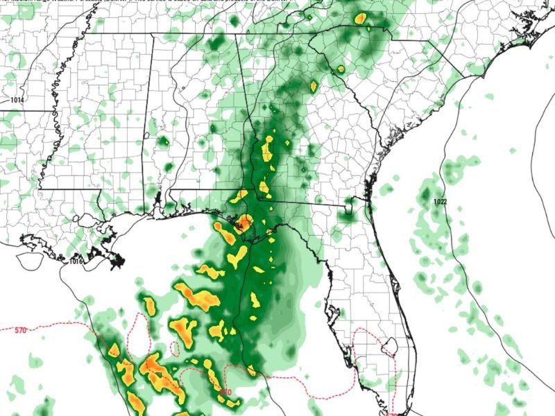
The map shows a noticeable band of rain developing over eastern Texas and Louisiana, then extending north and east into Mississippi and parts of Alabama. This suggests a more organized system compared to the scattered and limited activity seen in recent days.
While this is still several days out, it marks the first strong indication of a pattern change.
Rain Band Focused From Texas to Alabama
The projected rainfall zone is concentrated primarily across:
- Eastern and central Texas
- Much of Louisiana
- Large portions of Mississippi
- Parts of Alabama
Rainfall intensity appears highest closer to the Gulf Coast, where deeper moisture is present. Some areas could see pockets of heavier rain embedded within broader zones of lighter showers.
Not a Widespread Severe Setup at This Stage
At this point, the data does not strongly indicate a severe weather outbreak. Instead, this looks more like a typical spring rain event, with scattered showers and localized heavier bursts rather than widespread storms. However, details regarding intensity and timing may evolve as newer model data becomes available.
Forecast Still Several Days Away
Because this system is still developing in the longer-range forecast window, changes are possible. The exact track of the rain band, how far north or east it extends, and how much rain falls in each location could shift in the coming days. Forecast confidence will increase as April 5 gets closer.
A Potential Shift Toward More Active Weather
This developing system could mark the beginning of a more active weather pattern for the Gulf Coast and Deep South. After a quiet stretch, additional systems may follow into early April, bringing more consistent rain chances back into the region.
Are you in Texas, Louisiana, Mississippi, or Alabama and waiting for rain to return, or have you been enjoying the dry weather? Share your thoughts with us at SaludaStandard-Sentinel.com.