Texas, Oklahoma, Arkansas, Louisiana, Mississippi, Alabama, Tennessee and Missouri Face Multi-Day Severe Weather Threat With Tornadoes, Hail and Flooding Risk March 29 Through April 4
UNITED STATES — A significant multi-day severe weather pattern is expected to develop between March 29 and April 4, impacting a large stretch of the central and southern United States.
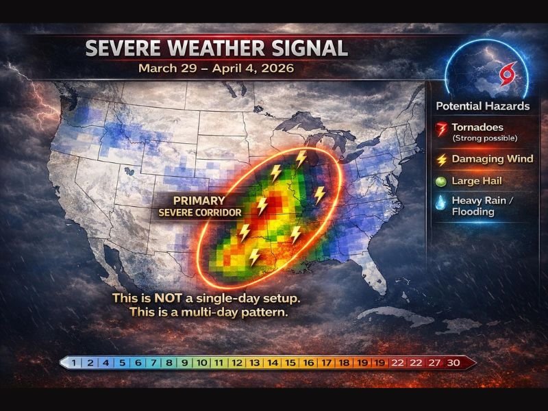
Forecast data shows a “primary severe corridor” setting up from parts of Texas and Oklahoma through Arkansas, Louisiana, Mississippi, Alabama, Tennessee, and into Missouri, raising concerns for repeated rounds of dangerous storms.
Multi-Day Storm Pattern Raises Concern Across Central U.S.
Unlike typical short-lived storm systems, this setup is expected to persist over several days, increasing the risk of multiple severe weather episodes across the same regions.
Meteorologists emphasize that this is not a one-day event, but rather a prolonged pattern that could bring waves of storms moving through the same corridor.
This kind of setup often leads to cumulative impacts, especially in areas that see repeated rainfall and storm activity.
Tornadoes, Damaging Winds and Large Hail All Possible
Forecast models indicate several severe weather hazards could develop throughout this period.
The greatest concerns include the potential for tornadoes, damaging wind gusts, and large hail in stronger storm cells. Some storms could become intense depending on how atmospheric instability and wind shear evolve.
While not every location will experience severe weather, conditions appear favorable for scattered to widespread storm development across the highlighted region.
Heavy Rainfall Could Lead to Flooding Issues
In addition to severe storms, heavy rainfall is expected to accompany this system, particularly in areas that receive multiple rounds of precipitation.
Localized flooding could become a concern, especially in low-lying or flood-prone regions where water can accumulate quickly.
The repeated nature of storms over several days increases the risk of saturated ground and runoff issues.
Gulf Coast and Southern States Urged to Stay Alert
Communities across the Gulf Coast and Deep South are being urged to closely monitor the forecast as conditions evolve.
States including Louisiana, Mississippi, Alabama, and parts of Texas are expected to be among the areas with higher storm potential during this period.
Residents are encouraged to review safety plans, secure outdoor items, and remain prepared for possible severe weather alerts.
Forecast Uncertainty Still Exists
Meteorologists note that while confidence is growing in a severe weather pattern, some uncertainty remains regarding exact storm placement and intensity.
Small shifts in the track of the system or timing of key atmospheric features could influence where the strongest storms ultimately develop.
As a result, forecast updates over the coming days will be critical in refining the threat areas.
Preparedness Key Ahead of Active Weather Period
With the potential for multiple hazards over several days, preparedness will be essential for those in the impacted regions.
Having multiple ways to receive weather alerts, identifying safe shelter locations, and staying aware of changing conditions can make a significant difference during severe weather events.
If you live in any of the impacted states and are preparing for this multi-day storm threat, share your plans or concerns with us. Stay connected with SaludaStandard-Sentinel.com for continuing updates as this severe weather pattern develops.