Pennsylvania Faces Sunday Severe Weather Threat With Damaging Winds and Quarter-Size Hail Risk South of I-80 Into Evening
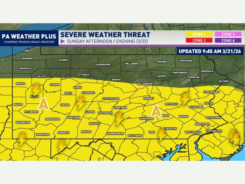
PENNSYLVANIA — A developing weather system is expected to bring a round of strong to severe thunderstorms across parts of Pennsylvania on Sunday, with the greatest risk focused along and south of the I-80 corridor.
Forecasters say a cold front moving into the region Sunday afternoon and evening will create conditions favorable for isolated severe storms capable of producing damaging winds and hail.
Cold Front Triggers Severe Weather Setup
The incoming cold front is expected to move into Pennsylvania during the afternoon hours, interacting with unstable air and increasing wind shear across the region.
This combination will allow thunderstorms to develop and intensify, particularly in areas where atmospheric conditions overlap most effectively.
Meteorologists note that the strongest potential for severe weather will remain south of I-80, where instability and wind dynamics are expected to be more favorable.
Storm Timing Focused Between Afternoon and Evening Hours
Storms are expected to begin developing between 2 PM and 4 PM, initially forming in western Pennsylvania before moving south-southeast across the state.
Areas in far southern Pennsylvania may not see storm activity until later in the evening, closer to sunset, as the system progresses. This staggered timing means different regions will experience impacts at different points throughout the day.
Damaging Winds and Hail Main Concerns
The primary threats with these storms include wind gusts ranging from 45 to 55 mph, which could cause minor damage to trees and structures.
In addition, some of the stronger storms may produce hail up to the size of quarters, posing a risk to vehicles, roofs, and outdoor property.
While the overall risk is considered low-end, isolated storms could still become intense quickly and produce localized impacts.
Risk Area Covers Much of Central and Southern Pennsylvania
The highlighted risk zone includes a broad portion of central and southern Pennsylvania, including areas near Pittsburgh, Harrisburg, Altoona, and extending toward eastern parts of the state.
Although storms are expected to be scattered rather than widespread, any location within this zone could see brief periods of severe weather.
Forecasters also note that the risk level could be upgraded if conditions become more favorable as the system develops.
Residents Urged to Stay Weather-Aware and Prepared
Officials emphasize that not every community will experience severe weather, but those that do could face sudden and intense conditions.
Residents are encouraged to have multiple ways to receive weather alerts and to identify a safe place to take shelter if warnings are issued. Preparation remains key, especially during early spring when weather patterns can shift quickly and unpredictably.
If you experience severe weather in your area, share your updates with us. Stay connected with SaludaStandard-Sentinel.com for continued coverage and real-time updates on this developing storm system.